IMAGES TAKEN NEAR TO
Wiltshire Road, SALISBURY, SP2 8HS
Introduction
This page details the photographs taken nearby to Wiltshire Road, SP2 8HS by members of the Geograph project.
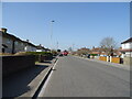
The Geograph project started in 2005 with the aim of publishing, organising and preserving representative images for every square kilometre of Great Britain, Ireland and the Isle of Man.

There are currently over 7.5m images from over14,400 individuals and you can help contribute to the project by visiting https://www.geograph.org.uk
Image Map (Loading...)


Getting Data...Please wait
Leaflet Map data © OpenStreetMap
Images are licensed for reuse under creativecommons.org/licenses/by-sa/2.0
Notes
- Clicking on the map will re-center to the selected point.
- The higher the marker number, the further away the image location is from the centre of the postcode.
Image Listing (116 Images Found)
Images are licensed for reuse under creativecommons.org/licenses/by-sa/2.0
Image
Details
Distance
2
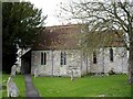
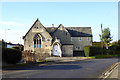
St George's church, Harnham
The south side of the church, situated in Harnham, across the water meadows from Salisbury.
Image: © Peter Jordan
Taken: 14 Apr 2006
0.08 miles
4
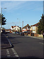
Netherhampton Road Looking West
The B3094.
Image: © Maigheach-gheal
Taken: 14 Jan 2007
0.10 miles
5
Former school, Harnham
From about 1850, grade II listed. Believed to be offices now.
Image: © Robin Webster
Taken: 16 Dec 2017
0.10 miles
6
![Salisbury buildings [13]](https://s1.geograph.org.uk/geophotos/06/39/19/6391993_78eab9eb_120x120.jpg)
Salisbury buildings [13]
The Old School at the junction of Lower Road and Netherhampton Road was built in 1863. It became a school for infants only in 1928 and closed in 1931. The school and schoolhouse were sold in 1951 and currently houses a taxi company. Listed, grade II, with details at: https://historicengland.org.uk/listing/the-list/list-entry/1258223
A cathedral was established at the Iron Age hillfort of Old Sarum by the Normans. In 1220 the cathedral was removed to the nearby plain and New Sarum (Salisbury) grew up around it, receiving a city charter in 1227. Located at the confluence of five rivers (Avon, Nadder, Ebble, Wylye and Bourne) the city is prone to flooding. Traffic between the ports of Southampton and Bristol, passes around the city's ring-road via the A36 causing much congestion.
Image: © Michael Dibb
Taken: 31 Dec 2019
0.10 miles
7
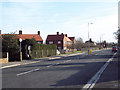
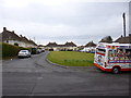
Looking East Along Netherhapton Road
The B3094.
Image: © Maigheach-gheal
Taken: 14 Jan 2007
0.11 miles
8
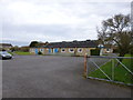
Harnham, church hall
On Middle Street, overlooking the recreation ground.
Image: © Mike Faherty
Taken: 14 Apr 2013
0.11 miles
9

Harnham, barn
Overlooking the recreation ground.
Image: © Mike Faherty
Taken: 14 Apr 2013
0.11 miles
10
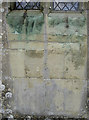
The stains of the years
Green copper-basaed minerals have leached out of the window frames and discoloured the stonework of St George's church.
Image: © Neil Owen
Taken: 16 May 2012
0.11 miles