IMAGES TAKEN NEAR TO
St. Georges Close, Lower Street, SALISBURY, SP2 8HA
Introduction
This page details the photographs taken nearby to St. Georges Close, Lower Street, SP2 8HA by members of the Geograph project.
The Geograph project started in 2005 with the aim of publishing, organising and preserving representative images for every square kilometre of Great Britain, Ireland and the Isle of Man.

There are currently over 7.5m images from over14,400 individuals and you can help contribute to the project by visiting https://www.geograph.org.uk
Image Map
Images are licensed for reuse under creativecommons.org/licenses/by-sa/2.0
Notes
- Clicking on the map will re-center to the selected point.
- The higher the marker number, the further away the image location is from the centre of the postcode.
Image Listing (164 Images Found)
Images are licensed for reuse under creativecommons.org/licenses/by-sa/2.0
Image
Details
Distance
2
![Salisbury houses [6]](https://s1.geograph.org.uk/geophotos/06/39/14/6391461_427e1d44_120x120.jpg)
Salisbury houses [6]
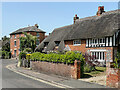
Elim is one of three 16th century timber framed cottages under a single thatched roof. The other cottages are Hunters Cottage Image and The Old Cottage Image Listed, grade II, with details at: https://historicengland.org.uk/listing/the-list/list-entry/1242800
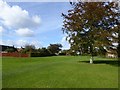
A cathedral was established at the Iron Age hillfort of Old Sarum by the Normans. In 1220 the cathedral was removed to the nearby plain and New Sarum (Salisbury) grew up around it, receiving a city charter in 1227. Located at the confluence of five rivers (Avon, Nadder, Ebble, Wylye and Bourne) the city is prone to flooding. Traffic between the ports of Southampton and Bristol, passes around the city's ring-road via the A36 causing much congestion.
Image: © Michael Dibb
Taken: 31 Dec 2019
0.03 miles
3
![Salisbury houses [5]](https://s1.geograph.org.uk/geophotos/06/39/14/6391457_a56fd1a0_120x120.jpg)
Salisbury houses [5]
Hunters Cottage is the middle one of three 16th century timber framed cottages under a single thatched roof. The other cottages are The Old Cottage Image and Elim Image Listed, grade II, with details at: https://historicengland.org.uk/listing/the-list/list-entry/1242800
A cathedral was established at the Iron Age hillfort of Old Sarum by the Normans. In 1220 the cathedral was removed to the nearby plain and New Sarum (Salisbury) grew up around it, receiving a city charter in 1227. Located at the confluence of five rivers (Avon, Nadder, Ebble, Wylye and Bourne) the city is prone to flooding. Traffic between the ports of Southampton and Bristol, passes around the city's ring-road via the A36 causing much congestion.
Image: © Michael Dibb
Taken: 31 Dec 2019
0.03 miles
4

Harnham, River Avon
Looking downstream from near Image Snow has fallen since yesterday, but is not predicted to stay.
Image: © Mike Faherty
Taken: 18 Mar 2018
0.04 miles
5
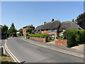
Old Mill Flats, The Old Cottage and Middle Thatched Cottage
Houses on Middle Street. Old Mill Flats, in the background, date from the late 18th/early 19th Century while the building in the foreground, split into 3 houses, dates from the 16th Century. Both are grade II listed - see https://historicengland.org.uk/listing/the-list/list-entry/1242808?section=official-list-entry and https://historicengland.org.uk/listing/the-list/list-entry/1242800?section=official-list-entry respectively.
Image: © Ian Capper
Taken: 17 Jun 2022
0.04 miles
6
![Salisbury houses [8]](https://s3.geograph.org.uk/geophotos/06/39/15/6391531_18edf941_120x120.jpg)
Salisbury houses [8]
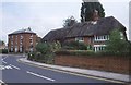
A view from the churchyard of the rear of Manor Farmhouse. Built in the late 18th century and added to in the early 19th century. Listed, grade II, with details at: https://historicengland.org.uk/listing/the-list/list-entry/1242796
A cathedral was established at the Iron Age hillfort of Old Sarum by the Normans. In 1220 the cathedral was removed to the nearby plain and New Sarum (Salisbury) grew up around it, receiving a city charter in 1227. Located at the confluence of five rivers (Avon, Nadder, Ebble, Wylye and Bourne) the city is prone to flooding. Traffic between the ports of Southampton and Bristol, passes around the city's ring-road via the A36 causing much congestion.
Image: © Michael Dibb
Taken: 31 Dec 2019
0.04 miles
7
![Salisbury houses [9]](https://s3.geograph.org.uk/geophotos/06/39/15/6391535_0b923d15_120x120.jpg)
Salisbury houses [9]
A glimpse of the front of Manor Farmhouse, a view of the rear is at Image Built in the late 18th century and added to in the early 19th century. Listed, grade II, with details at: https://historicengland.org.uk/listing/the-list/list-entry/1242796
A cathedral was established at the Iron Age hillfort of Old Sarum by the Normans. In 1220 the cathedral was removed to the nearby plain and New Sarum (Salisbury) grew up around it, receiving a city charter in 1227. Located at the confluence of five rivers (Avon, Nadder, Ebble, Wylye and Bourne) the city is prone to flooding. Traffic between the ports of Southampton and Bristol, passes around the city's ring-road via the A36 causing much congestion.
Image: © Michael Dibb
Taken: 31 Dec 2019
0.04 miles
8
Old Mill Flats, The Old Cottage and Middle Thatched Cottage
Houses on Middle Street. Old Mill Flats, in the background, date from the late 18th/early 19th Century while the building in the foreground, split into 3 houses, dates from the 16th Century. Both are grade II listed - see https://historicengland.org.uk/listing/the-list/list-entry/1242808?section=official-list-entry and https://historicengland.org.uk/listing/the-list/list-entry/1242800?section=official-list-entry respectively.
Image: © Ian Capper
Taken: 17 Jun 2022
0.04 miles
9
Old Mill House and Hunters Cottage, Harnham
Both buildings are Grade II listed.
Image: © Richard Sutcliffe
Taken: 21 Aug 1981
0.04 miles
10
![Salisbury houses [4]](https://s2.geograph.org.uk/geophotos/06/39/14/6391454_a3c2f4b3_120x120.jpg)
Salisbury houses [4]
The Old Cottage is one of three 16th century timber framed cottages under a single thatched roof. The other cottages are Hunters Cottage Image and Elim Image Listed, grade II, with details at: https://historicengland.org.uk/listing/the-list/list-entry/1242800
A cathedral was established at the Iron Age hillfort of Old Sarum by the Normans. In 1220 the cathedral was removed to the nearby plain and New Sarum (Salisbury) grew up around it, receiving a city charter in 1227. Located at the confluence of five rivers (Avon, Nadder, Ebble, Wylye and Bourne) the city is prone to flooding. Traffic between the ports of Southampton and Bristol, passes around the city's ring-road via the A36 causing much congestion.
Image: © Michael Dibb
Taken: 31 Dec 2019
0.04 miles