IMAGES TAKEN NEAR TO
Ayleswade Road, SALISBURY, SP2 8DR
Introduction
This page details the photographs taken nearby to Ayleswade Road, SP2 8DR by members of the Geograph project.
The Geograph project started in 2005 with the aim of publishing, organising and preserving representative images for every square kilometre of Great Britain, Ireland and the Isle of Man.

There are currently over 7.5m images from over14,400 individuals and you can help contribute to the project by visiting https://www.geograph.org.uk
Image Map
Images are licensed for reuse under creativecommons.org/licenses/by-sa/2.0
Notes
- Clicking on the map will re-center to the selected point.
- The higher the marker number, the further away the image location is from the centre of the postcode.
Image Listing (203 Images Found)
Images are licensed for reuse under creativecommons.org/licenses/by-sa/2.0
Image
Details
Distance
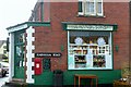
3
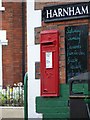
George V Postbox, Harnham
The postbox is on Harnham Road.
Image: © Maigheach-gheal
Taken: 16 Jul 2008
0.03 miles
4
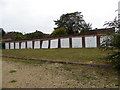
Garages near the Greyfisher
This block of garages have not been used since 2006 when the land owner Greene King served notice on the tenants.
Image: © Maigheach-gheal
Taken: 21 Oct 2011
0.03 miles
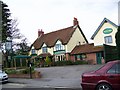
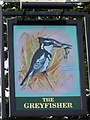
5
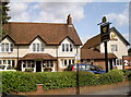
The Greyfisher
Having spruced the place up a bit, the sign featuring the bird is now replaced by a simpler version.
Image: © Neil Owen
Taken: 4 Aug 2014
0.03 miles
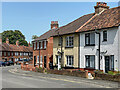
6
Harnham Road
An old-fashioned type confectioners on Harnham Road, junction with Ayleswade Road.
Image: © Graham Horn
Taken: 4 Dec 2008
0.04 miles
7
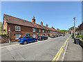
29 - 33 Harnham Road
Row of cottages on Harnham Road.
Image: © Ian Capper
Taken: 17 Jun 2022
0.04 miles
8
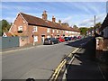
Terraced houses, Harnham Road
Those at the far end show the local style of mixed facade with flint detail, the nearer ones are brick
Image: © David Smith
Taken: 18 Oct 2016
0.05 miles
9
2 - 14 Harnham Road
18th/19th century terrace on Harnham Road. Grade II listed - see https://historicengland.org.uk/listing/the-list/list-entry/1023676?section=official-list-entry.
Image: © Ian Capper
Taken: 17 Jun 2022
0.05 miles
10
![Salisbury houses [17]](https://s2.geograph.org.uk/geophotos/06/39/28/6392814_80fa3121_120x120.jpg)
Salisbury houses [17]
The even numbers 2 to 14 Harnham Road are a terrace of late 18th/early 19th century houses in three slightly different designs. Listed, grade II, with details at: https://historicengland.org.uk/listing/the-list/list-entry/1023676
A cathedral was established at the Iron Age hillfort of Old Sarum by the Normans. In 1220 the cathedral was removed to the nearby plain and New Sarum (Salisbury) grew up around it, receiving a city charter in 1227. Located at the confluence of five rivers (Avon, Nadder, Ebble, Wylye and Bourne) the city is prone to flooding. Traffic between the ports of Southampton and Bristol, passes around the city's ring-road via the A36 causing much congestion.
Image: © Michael Dibb
Taken: 31 Dec 2019
0.05 miles