IMAGES TAKEN NEAR TO
Fisherton Street, SALISBURY, SP2 7SS
Introduction
This page details the photographs taken nearby to Fisherton Street, SP2 7SS by members of the Geograph project.
The Geograph project started in 2005 with the aim of publishing, organising and preserving representative images for every square kilometre of Great Britain, Ireland and the Isle of Man.

There are currently over 7.5m images from over14,400 individuals and you can help contribute to the project by visiting https://www.geograph.org.uk
Image Map (Loading...)


Getting Data...Please wait
Leaflet Map data © OpenStreetMap
Images are licensed for reuse under creativecommons.org/licenses/by-sa/2.0
Notes
- Clicking on the map will re-center to the selected point.
- The higher the marker number, the further away the image location is from the centre of the postcode.
Image Listing (775 Images Found)
Images are licensed for reuse under creativecommons.org/licenses/by-sa/2.0
Image
Details
Distance
1
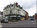
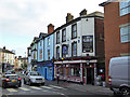
![Salisbury buildings [34]](https://s3.geograph.org.uk/geophotos/06/39/47/6394703_b152881d_120x120.jpg)
Salisbury buildings [34]
This interesting wedge shaped building at 109 Fisherton Street is home to a florists.
A cathedral was established at the Iron Age hillfort of Old Sarum by the Normans. In 1220 the cathedral was removed to the nearby plain and New Sarum (Salisbury) grew up around it, receiving a city charter in 1227. Located at the confluence of five rivers (Avon, Nadder, Ebble, Wylye and Bourne) the city is prone to flooding. Traffic between the ports of Southampton and Bristol, passes around the city's ring-road via the A36 causing much congestion.
Image: © Michael Dibb
Taken: 31 Dec 2019
0.00 miles
2
Salisbury: junction of Dew's Road with South Western Road
A very busy mini-roundabout beside the railway bridge across Fisherton Street. The station is a little way up South Western Road on the right.
Image: © Derek Harper
Taken: 9 Jul 2009
0.01 miles
3
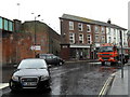
Wet conditions at the junction of Fisherton Street and South Western Road
Image: © Basher Eyre
Taken: 1 Jun 2010
0.01 miles
4
The Shah Jahan in Salisbury
Indian cuisine restaurant at 111-113 South Western Road. The car is entering Dew's Road.
Image: © Jaggery
Taken: 21 Sep 2013
0.01 miles
5
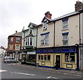
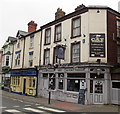
Railway Tavern
Pub on Fisherton Street, Salisbury.
Image: © Wayland Smith
Taken: 9 Aug 2020
0.01 miles
6
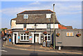
The Cat Tavern, Salisbury
On South Western Road.
Image: © Robin Webster
Taken: 16 Dec 2017
0.01 miles
7
The Cat Tavern, Salisbury
Viewed across South Western Road.
Image: © Jaggery
Taken: 21 Sep 2013
0.01 miles
8
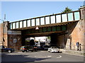
Fisherton Street bridge
The bridge carries the First Great Western and South West Trains traffic. See Image] for a closer look at the crest in the middle.
Image: © Neil Owen
Taken: 28 Mar 2012
0.01 miles
9
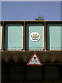
Mind your head
Or you might hit Salisbury's coat of arms! The inscription reads: 'Civilas Novae Sarum' and dates back to the sixteenth century. The lower sign dates back to a more modern time.
Image: © Neil Owen
Taken: 28 Mar 2012
0.01 miles
10
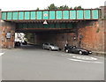
Fisherton Street railway bridge, Salisbury
Immediately east of Salisbury railway station, the bridge carries railway lines over the road.
Headroom shown is 14' 3". The left turn is South Western Road, the road to the station entrance. http://www.geograph.org.uk/photo/4110706
Image: © Jaggery
Taken: 21 Sep 2013
0.01 miles