IMAGES TAKEN NEAR TO
Fisherton Street, SALISBURY, SP2 7RP
Introduction
This page details the photographs taken nearby to Fisherton Street, SP2 7RP by members of the Geograph project.
The Geograph project started in 2005 with the aim of publishing, organising and preserving representative images for every square kilometre of Great Britain, Ireland and the Isle of Man.

There are currently over 7.5m images from over14,400 individuals and you can help contribute to the project by visiting https://www.geograph.org.uk
Image Map (Loading...)


Getting Data...Please wait
Leaflet Map data © OpenStreetMap
Images are licensed for reuse under creativecommons.org/licenses/by-sa/2.0
Notes
- Clicking on the map will re-center to the selected point.
- The higher the marker number, the further away the image location is from the centre of the postcode.
Image Listing (563 Images Found)
Images are licensed for reuse under creativecommons.org/licenses/by-sa/2.0
Image
Details
Distance
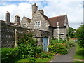
1
Salisbury - St Paul's Home
St Pauls Homes are a set of three almshouses built in 1863 with another three being built in 1868. In 1965 the Salisbury branch of the Roundtable converted the houses into twelve flats. The flats were occupied until 2005 when the last tenant moved out as the flats were becoming run down. The flats are the subject of a fund raising drive to enable the building to be returned to its original purpose.
Image: © Chris Talbot
Taken: 10 Jul 2011
0.02 miles
2
Salisbury - St Paul's Home
St Pauls Homes are a set of three almshouses built in 1863 with another three being built in 1868. In 1965 the Salisbury branch of the Roundtable converted the houses into twelve flats. The flats were occupied until 2005 when the last tenant moved out as the flats were becoming run down. The flats are the subject of a fund raising drive to enable the building to be returned to its original purpose.
Image: © Chris Talbot
Taken: 10 Jul 2011
0.02 miles
3
![Salisbury houses [34]](https://s1.geograph.org.uk/geophotos/06/39/47/6394713_b9fd0edb_120x120.jpg)
Salisbury houses [34]
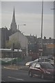
St Paul's Home, built in two stages in 1863 and 1868 comprises six almshouses, which were converted into 12 flats in 1961. The flats became empty and disused in 2005 but were restored and modernised in 2014. There is much detail at: http://www.crash.org.uk/projects/new-life-for-historic-st-pauls-homes/ The houses are listed, grade II, with details at: https://historicengland.org.uk/listing/the-list/list-entry/1242034
A cathedral was established at the Iron Age hillfort of Old Sarum by the Normans. In 1220 the cathedral was removed to the nearby plain and New Sarum (Salisbury) grew up around it, receiving a city charter in 1227. Located at the confluence of five rivers (Avon, Nadder, Ebble, Wylye and Bourne) the city is prone to flooding. Traffic between the ports of Southampton and Bristol, passes around the city's ring-road via the A36 causing much congestion.
Image: © Michael Dibb
Taken: 31 Dec 2019
0.02 miles
4
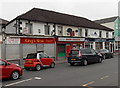
King's Wok, Salisbury
Chinese takeaway viewed through heavy traffic in Fisherton Street.
Also in view are Bhavish Newsagents and Carpet House.
Image: © Jaggery
Taken: 21 Sep 2013
0.02 miles
5
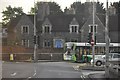
Salisbury : St Paul's Roundabout
Heading around St Paul's Roundabout in Salisbury.
Image: © Lewis Clarke
Taken: 23 Aug 2012
0.02 miles
6
Salisbury : St Paul's Roundabout
Heading around St Paul's Roundabout with the cathedral in the background.
Image: © Lewis Clarke
Taken: 23 Aug 2012
0.02 miles
7

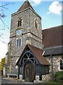
Salisbury - St Pauls Church
This replaced the Church of St. Clement, demolished in 1852, to serve the expanding population of this area. The foundation stone was laid in 1851 and the church consecrated in 1853.
Image: © Chris Talbot
Taken: 17 Oct 2008
0.03 miles
8
Salisbury - St Pauls Church
The clock tower of St Pauls Church.
Image: © Chris Talbot
Taken: 17 Oct 2008
0.03 miles
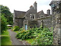
9
Salisbury - Houses
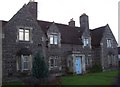
These houses stand in the grounds of St Pauls Church.
Image: © Chris Talbot
Taken: 17 Oct 2008
0.03 miles
10
Salisbury - Street
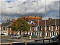
The view from the steps of St Pauls Church.
Image: © Chris Talbot
Taken: 17 Oct 2008
0.03 miles