IMAGES TAKEN NEAR TO
Churchfields Road, SALISBURY, SP2 7NW
Introduction
This page details the photographs taken nearby to Churchfields Road, SP2 7NW by members of the Geograph project.
The Geograph project started in 2005 with the aim of publishing, organising and preserving representative images for every square kilometre of Great Britain, Ireland and the Isle of Man.

There are currently over 7.5m images from over14,400 individuals and you can help contribute to the project by visiting https://www.geograph.org.uk
Image Map (Loading...)


Getting Data...Please wait
Leaflet Map data © OpenStreetMap
Images are licensed for reuse under creativecommons.org/licenses/by-sa/2.0
Notes
- Clicking on the map will re-center to the selected point.
- The higher the marker number, the further away the image location is from the centre of the postcode.
Image Listing (273 Images Found)
Images are licensed for reuse under creativecommons.org/licenses/by-sa/2.0
Image
Details
Distance
1
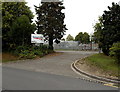
Access road to Network Rail, Salisbury
From Churchfields Road near Salisbury railway station. Network Rail's website succinctly describes their business: "We own and operate Britain's rail infrastructure".
Image: © Jaggery
Taken: 21 Sep 2013
0.02 miles
2
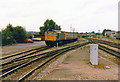
Class 33 at Salisbury, 1986
In the summer of 1986 a Class 33 diesel-electric locomotive, No 33048, rests in a siding close to Salisbury station as a westbound freight train moves away in the distance.
Image: © Rob Newman
Taken: 1 Aug 1986
0.03 miles
3
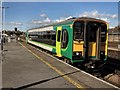
Salisbury - Railway Station
According to a train spotter I met on the platform this train is rather a strange visitor to Salisbury, It stopped for a few minutes and moved off towards the west country.
Image: © Chris Talbot
Taken: 17 Oct 2008
0.03 miles
4

Salisbury Furniture Shop
The Trussell Trust shop is at 1 Stephenson Road, viewed from Churchfields Road. Trussell Trust charity shops are designed to do more than just raise funds. Each shop aims to become a hub of the local community by providing:
● A listening service for people in emotional distress.
● Volunteering opportunities for people with mental, social or physical difficulties.
●Affordable goods for people on low incomes.
●Emergency food for people in crisis, through a local foodbank.
Image: © Jaggery
Taken: 21 Sep 2013
0.04 miles
5

SCATS Countrystores in Salisbury
Viewed across Churchfields Road. This is one of 18 SCATS Countrystores in southern England and South Wales selling a wide range of farming and rural products, such as equestrian supplies & clothing, casual & workwear clothing, household & gardening products and locally-sourced food and drink.
SCATS is the acronym of Southern Counties Agricultural Trading Society.
Image: © Jaggery
Taken: 21 Sep 2013
0.04 miles
6
Entering Salisbury Station
From a train from Exeter entering the station from the west, with a shed on the right. Over the wall on the left are new buildings at the hospital.
Image: © Derek Harper
Taken: 29 Apr 2013
0.05 miles
7

Nadder Terrace, Salisbury
On the south side of Churchfields Road, near the water meadows
where the River Nadder flows into the River Avon.
Image: © Jaggery
Taken: 21 Sep 2013
0.05 miles
9
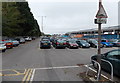
Salisbury railway station car park
Located beyond the western edge of the main station buildings, http://www.geograph.org.uk/photo/3938629
the car park has space for nearly 300 cars.
Image: © Jaggery
Taken: 21 Sep 2013
0.06 miles
10
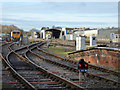
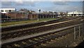
Railway west of Salisbury station
A tamper in an engineer's compound on the left, a washer and what could be a refuelling shed on the other side of the running lines.
Image: © Robin Webster
Taken: 16 Dec 2017
0.06 miles