IMAGES TAKEN NEAR TO
Churchfields Road, SALISBURY, SP2 7NL
Introduction
This page details the photographs taken nearby to Churchfields Road, SP2 7NL by members of the Geograph project.
The Geograph project started in 2005 with the aim of publishing, organising and preserving representative images for every square kilometre of Great Britain, Ireland and the Isle of Man.

There are currently over 7.5m images from over14,400 individuals and you can help contribute to the project by visiting https://www.geograph.org.uk
Image Map (635 Images)


Leaflet Map data © OpenStreetMap
Images are licensed for reuse under creativecommons.org/licenses/by-sa/2.0
Notes
- Clicking on the map will re-center to the selected point.
- The higher the marker number, the further away the image location is from the centre of the postcode.
Image Listing (635 Images Found)
Images are licensed for reuse under creativecommons.org/licenses/by-sa/2.0
Image
Details
Distance
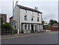
1
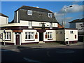
Railway Tavern
Local Pub next to Salisbury Railway Station
Image: © Jim Goldsmith
Taken: 17 May 2007
0.01 miles
2
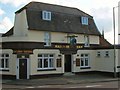
Salisbury - The Railway Tavern
This tavern is at the top of Fisherton Street close to the railway station.
Image: © Chris Talbot
Taken: 17 Oct 2008
0.01 miles
3
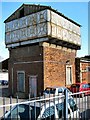
Salisbury - Railway Station
This water tower seems to have been unused for sometime.
Image: © Chris Talbot
Taken: 17 Oct 2008
0.01 miles
4
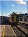
Salisbury - Railway Station
A train arriving at Salisbury from Andover.
Image: © Chris Talbot
Taken: 17 Oct 2008
0.01 miles
5
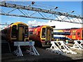
Salisbury - Railway Station
Trains in the maintenance depot.
Image: © Chris Talbot
Taken: 17 Oct 2008
0.01 miles
6
Salisbury - Railway Station
Part of an area of office buildings in the station yard.
Image: © Chris Talbot
Taken: 17 Oct 2008
0.01 miles
7
South Lodge, Salisbury
3-storey house, Churchfields Road.
Image: © Jaggery
Taken: 21 Sep 2013
0.01 miles
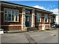
8
Salisbury Station
The entrance to the station of 1902 - a new building for the London and South Western Railway.
Image: © Neil Owen
Taken: 27 Oct 2014
0.02 miles
9
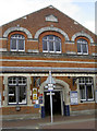
![Salisbury buildings [32]](https://s0.geograph.org.uk/geophotos/06/39/47/6394700_9654ef57_120x120.jpg)
Salisbury buildings [32]
Detail of the decorative wrought iron brackets supporting the canopy which runs the width of the entrance block.
This part of Salisbury railway station was built in 1902 and supplemented the 1859 part to the south. This station was opened by the London and South Western Railway. The Great Western Railway ran into a separate station Image until 1932. Listed, grade II, with much detail at: https://historicengland.org.uk/listing/the-list/list-entry/1392847
A cathedral was established at the Iron Age hillfort of Old Sarum by the Normans. In 1220 the cathedral was removed to the nearby plain and New Sarum (Salisbury) grew up around it, receiving a city charter in 1227. Located at the confluence of five rivers (Avon, Nadder, Ebble, Wylye and Bourne) the city is prone to flooding. Traffic between the ports of Southampton and Bristol, passes around the city's ring-road via the A36 causing much congestion.
Image: © Michael Dibb
Taken: 31 Dec 2019
0.02 miles
10
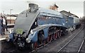
Sir Nigel Gresley at Salisbury
The Blackmore Vale Express to Yeovil
Image: © John Firth
Taken: 19 Oct 1986
0.02 miles