IMAGES TAKEN NEAR TO
Sarum Close, SALISBURY, SP2 7LE
Introduction
This page details the photographs taken nearby to Sarum Close, SP2 7LE by members of the Geograph project.
The Geograph project started in 2005 with the aim of publishing, organising and preserving representative images for every square kilometre of Great Britain, Ireland and the Isle of Man.

There are currently over 7.5m images from over14,400 individuals and you can help contribute to the project by visiting https://www.geograph.org.uk
Image Map (Loading...)


Getting Data...Please wait
Leaflet Map data © OpenStreetMap
Images are licensed for reuse under creativecommons.org/licenses/by-sa/2.0
Notes
- Clicking on the map will re-center to the selected point.
- The higher the marker number, the further away the image location is from the centre of the postcode.
Image Listing (47 Images Found)
Images are licensed for reuse under creativecommons.org/licenses/by-sa/2.0
Image
Details
Distance
1
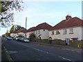
The Devizes Rd
This is the A360 north west of the town centre of Salisbury looking north away from the roundabout which is at the junction with Highbury Rd.
Image: © Nigel Mykura
Taken: 30 Oct 2010
0.05 miles
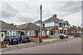
2
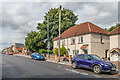
Devizes Road
c.1920s/30s housing first marked on the 1939 25 inch map.
Image: © Ian Capper
Taken: 22 Sep 2022
0.07 miles
3
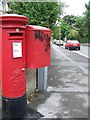
George V Postbox, Salisbury
The postbox is on the A360, Devizes Road.
Image: © Maigheach-gheal
Taken: 3 Aug 2008
0.07 miles
4
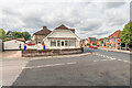
199 Devizes Road
House on the corner of India Road and Devizes Road. For a close up of the "Girl with balloon" mural on the garage, see Image
Image: © Ian Capper
Taken: 22 Sep 2022
0.08 miles
5
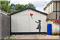
Girl with Balloon
"Girl with Balloon" mural on a garage at 199 Devizes Road - presumably a replica not a genuine Banksy work. For a wider view see Image
Image: © Ian Capper
Taken: 22 Sep 2022
0.09 miles
6
India Avenue
c.1920s/30s housing first marked on the 1938 25 inch map, one of a group of four roads named after countries in the (then) British Empire. On that map it was named Indian Avenue.
Image: © Ian Capper
Taken: 22 Sep 2022
0.11 miles
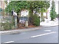
7
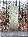
Milestone, Devizes Road
Milestone beside the A360, Devizes Road. The plate is missing but the bench mark is very clear. For a wider view see Image
Image: © Maigheach-gheal
Taken: 12 Jan 2010
0.14 miles
8
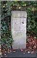
Old Milestone by the A360, Devizes Road, Bemerton, Salisbury
Stone post (plate lost) by the A360, in parish of SALISBURY (SALISBURY District), Devizes Road, Bemerton; opposite No.224, by the road, on West side of road. Salisbury plate, erected by the Fisherton, Wilton, Heytesbury, Willoughby Hedge & Redhone turnpike trust in the 19th century.
Inscription once read:-
(Devizes)
(22)
(Salisbury
(1)
Carved benchmark lower front.
Milestone Society National ID: WI_DZSA22.
Image: © M Faherty
Taken: 20 Jan 2007
0.15 miles
9
Milestone, Devizes Road
Milestone beside the A36, Devizes Road.
Image: © Maigheach-gheal
Taken: 12 Jan 2010
0.15 miles
10
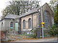
Fisherton Water Works
A modern brick building on the Devizes Road actually dates from the mid/late-1800s. It is part of the site that includes a covered reservoir and various pipes and valves. The site was open fields in the past, with a few prehistoric, Iron Age and Roman discovered. In 1866 some human remains were discovered close by and at the time a number of industries were started up; the local soil is chalky and hence there were chalk pits and brick kilns that flourished in the latter 1800s, but were largely finished by the turn of the century.
See Image] for a view of some of the pipework.
Image: © Neil Owen
Taken: 27 Oct 2014
0.15 miles