IMAGES TAKEN NEAR TO
Spire View, SALISBURY, SP2 7GP
Introduction
This page details the photographs taken nearby to Spire View, SP2 7GP by members of the Geograph project.
The Geograph project started in 2005 with the aim of publishing, organising and preserving representative images for every square kilometre of Great Britain, Ireland and the Isle of Man.

There are currently over 7.5m images from over14,400 individuals and you can help contribute to the project by visiting https://www.geograph.org.uk
Image Map
Images are licensed for reuse under creativecommons.org/licenses/by-sa/2.0
Notes
- Clicking on the map will re-center to the selected point.
- The higher the marker number, the further away the image location is from the centre of the postcode.
Image Listing (245 Images Found)
Images are licensed for reuse under creativecommons.org/licenses/by-sa/2.0
Image
Details
Distance
1
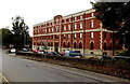
Dunn's House, Salisbury
5-storey office building in St Paul's Road, located alongside the A36 Churchill Way West.
Image: © Jaggery
Taken: 21 Sep 2013
0.04 miles
2
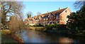
Salisbury - River Avon
The River Avon as it flows past these houses on the edge of the city centre.
Image: © Chris Talbot
Taken: 1 Jan 2010
0.05 miles
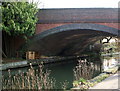
4
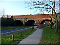
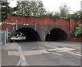
Railway bridge over car park access road, Salisbury
Possibly more a viaduct - it continues to cross the river off to the right. Because of its remarkably vegetated state, I assumed this was on a disused line, but not so. This is on the main line through Salisbury. I hope someone is keeping an eye on the brickwork, but it hard to see how.
Image: © Robin Webster
Taken: 16 Dec 2017
0.05 miles
5
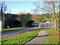
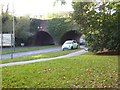
Railway bridge with 2.7 metre headroom in Salisbury
The road from Churchill Way West leads to a car park. The clearance under the bridge is shown as 2.7 metres (8' 9"). This applies only to the marked area above the centre of the road, because of the arch.
Image: © Jaggery
Taken: 21 Sep 2013
0.05 miles
6
Railway bridge over car park approach, Salisbury
The approach road to the car park leads off Churchill Way
Image: © David Smith
Taken: 18 Oct 2016
0.05 miles
7
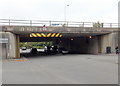
3.1 metre headroom under Churchill Way West, Salisbury
Orangey-yellow and black stripes on the bridge draw attention to the 3.1 metre (10' 3") overhead clearance.
Image: © Jaggery
Taken: 21 Sep 2013
0.05 miles
8
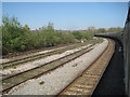
View from a Southampton-Salisbury train - railway curving away from Salisbury
Image: © Nigel Thompson
Taken: 8 Apr 2017
0.06 miles
9
Railway Bridge at Salisbury
A branch of the River Avon flows by the side of the car park into the town of Salisbury.
Image: © Gillian Thomas
Taken: 29 Jan 2008
0.06 miles
10
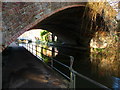
Salisbury - Railway Bridge
Underneath the arches...
Image: © Chris Talbot
Taken: 1 Jan 2010
0.06 miles