IMAGES TAKEN NEAR TO
Hawthorn Close, SALISBURY, SP2 7EQ
Introduction
This page details the photographs taken nearby to Hawthorn Close, SP2 7EQ by members of the Geograph project.
The Geograph project started in 2005 with the aim of publishing, organising and preserving representative images for every square kilometre of Great Britain, Ireland and the Isle of Man.

There are currently over 7.5m images from over14,400 individuals and you can help contribute to the project by visiting https://www.geograph.org.uk
Image Map
Images are licensed for reuse under creativecommons.org/licenses/by-sa/2.0
Notes
- Clicking on the map will re-center to the selected point.
- The higher the marker number, the further away the image location is from the centre of the postcode.
Image Listing (341 Images Found)
Images are licensed for reuse under creativecommons.org/licenses/by-sa/2.0
Image
Details
Distance
1
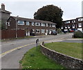
Hawthorn Close, Salisbury
On the north side of the A36 Wilton Road.
Image: © Jaggery
Taken: 21 Sep 2013
0.01 miles
2
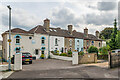
11 - 25 Hartington Road
19th Century terrace, first marked on the 1880 1:500 Plan as Model Row.
Image: © Ian Capper
Taken: 22 Sep 2022
0.03 miles
3
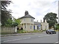
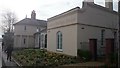
Salisbury, Quaker Meeting House
On Wilton Road: http://www.salisburyquakers.org/
Image: © Mike Faherty
Taken: 22 Jul 2017
0.04 miles
4
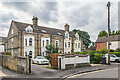
27 - 33 Hartington Road
Row of 19th Century villas, first marked on the 1880 1:500 Plan as Lawn Terrace.
Image: © Ian Capper
Taken: 22 Sep 2022
0.04 miles
5
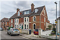
11 - 25 Hartington Road
Late 19th Century terrace, first marked on the 1901 25 inch map.
Image: © Ian Capper
Taken: 22 Sep 2022
0.04 miles
6
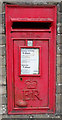
Elizabeth II postbox on Devizes Road, Salisbury
Postbox No. SP2 67.
See Image] for context.
Image: © JThomas
Taken: 13 Jul 2019
0.04 miles
7
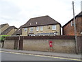
House on Devizes Road, Salisbury
Showing position of Postbox No. SP2 67.
See Image] for postbox.
Image: © JThomas
Taken: 13 Jul 2019
0.04 miles
8
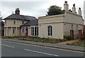
Quaker Meeting House in Salisbury
This has been a Quaker Meeting House since April 2010. The Wilton Road building, formerly known as Kennet Lodge, was converted to a Quaker meeting room, library, lobby, kitchen, and children and young people's rooms, with a flat upstairs.
Image: © Jaggery
Taken: 21 Sep 2013
0.05 miles
9
Salisbury Quaker Meeting House
The Society of Friends was founded by George Fox in the 17th century and is distinguished for having no ministers, meeting in silence and being strongly pacifist. Quakers were recorded in Salisbury as early as 1657 when Francis Taylor interrupted a sermon in the Cathedral and was thrown out and imprisoned. A Quaker meeting was established and held at various locations. In 2003 Salisbury Friends bought Kennet Lodge on Wilton Road, a grade II listed building in a poor state of repair. It was subsequently renovated for use by the Quaker Meeting, the first meeting being held in 2010.
Image: © Colin Cheesman
Taken: 4 Apr 2014
0.05 miles
10
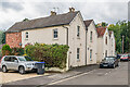
35 - 41 Hartington Road
Two pairs of late 19th Century semi-detached houses, first marked on the 1901 25 inch map.
Image: © Ian Capper
Taken: 22 Sep 2022
0.05 miles