IMAGES TAKEN NEAR TO
Christie Miller Road, SALISBURY, SP2 7EN
Introduction
This page details the photographs taken nearby to Christie Miller Road, SP2 7EN by members of the Geograph project.
The Geograph project started in 2005 with the aim of publishing, organising and preserving representative images for every square kilometre of Great Britain, Ireland and the Isle of Man.

There are currently over 7.5m images from over14,400 individuals and you can help contribute to the project by visiting https://www.geograph.org.uk
Image Map (Loading...)


Getting Data...Please wait
Leaflet Map data © OpenStreetMap
Images are licensed for reuse under creativecommons.org/licenses/by-sa/2.0
Notes
- Clicking on the map will re-center to the selected point.
- The higher the marker number, the further away the image location is from the centre of the postcode.
Image Listing (86 Images Found)
Images are licensed for reuse under creativecommons.org/licenses/by-sa/2.0
Image
Details
Distance
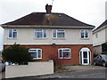
1
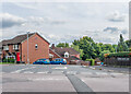
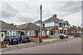
Christie Miller Road
Part of a c.1970s/80s estate built on the grounds of Bemerton Lodge, a name now retained by a care home on the site. The original Bemerton Lodge was home to Cecil Chubb, who donated Stonehenge to the nation. The Christie Miller family were owners of Clarendon Park, outside Salisbury, from c.1920 to 2006 and one of the buildings in Christie Miller Road is a home for adults with learning difficulties named Clarendon House, but I have not otherwise found any connection between the road and the surname.
Image: © Ian Capper
Taken: 22 Sep 2022
0.05 miles
2
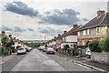
Canadian Avenue
c.1920s/30s housing first marked on the 1938 25 inch map, one of a group of four roads named after countries in the (then) British Empire.
Image: © Ian Capper
Taken: 22 Sep 2022
0.10 miles
3
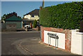
Harper Road, Salisbury
Can't be expected to resist this road name sign. The main road is St Gregory's Avenue.
Image: © Derek Harper
Taken: 30 Jun 2018
0.12 miles
4
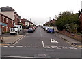
Canadian Avenue, Salisbury
Viewed across Wilton Road. Salisbury Antiques Centre http://www.geograph.org.uk/photo/3959788 is on the left.
Image: © Jaggery
Taken: 21 Sep 2013
0.12 miles
5
Semi-detached houses, Salisbury
Typical of the style of housing on Canadian Avenue. There is an Ordnance Survey bench mark on the east angle.
Image: © Maigheach-gheal
Taken: 9 Jan 2012
0.13 miles
6
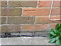
Bench Mark, Canadian Avenue
The Ordnance Survey bench mark is to be found on the east angle of the house. For a wider view of the building Image and for further information on the cut mark and others in the area http://www.bench-marks.org.uk/bm40891
Image: © Maigheach-gheal
Taken: 9 Jan 2012
0.13 miles
7
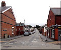
Highbury Avenue, Salisbury
Looking NNE across the A36 Wilton Road. Spire Memorials shop http://www.geograph.org.uk/photo/3939070 is on the right.
Image: © Jaggery
Taken: 21 Sep 2013
0.13 miles
8
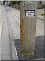
Too close for comfort
A new crossing point was installed in Highbury Avenue just a short distance from the entrance to the school here. Within a fortnight, a concrete mixer vehicle clouted it as it made its way to the new housing estate that is being built nearby. The large wooden post was damaged and uprooted from the ground - hence the fresh tarmac. There are no reports of any injuries.
Image: © Neil Owen
Taken: 27 Oct 2014
0.13 miles
9
India Avenue
c.1920s/30s housing first marked on the 1938 25 inch map, one of a group of four roads named after countries in the (then) British Empire. On that map it was named Indian Avenue.
Image: © Ian Capper
Taken: 22 Sep 2022
0.13 miles
10
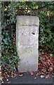
Old Milestone by the A360, Devizes Road, Bemerton, Salisbury
Stone post (plate lost) by the A360, in parish of SALISBURY (SALISBURY District), Devizes Road, Bemerton; opposite No.224, by the road, on West side of road. Salisbury plate, erected by the Fisherton, Wilton, Heytesbury, Willoughby Hedge & Redhone turnpike trust in the 19th century.
Inscription once read:-
(Devizes)
(22)
(Salisbury
(1)
Carved benchmark lower front.
Milestone Society National ID: WI_DZSA22.
Image: © M Faherty
Taken: 20 Jan 2007
0.14 miles