IMAGES TAKEN NEAR TO
Ashley Road, SALISBURY, SP2 7DF
Introduction
This page details the photographs taken nearby to Ashley Road, SP2 7DF by members of the Geograph project.
The Geograph project started in 2005 with the aim of publishing, organising and preserving representative images for every square kilometre of Great Britain, Ireland and the Isle of Man.

There are currently over 7.5m images from over14,400 individuals and you can help contribute to the project by visiting https://www.geograph.org.uk
Image Map
Images are licensed for reuse under creativecommons.org/licenses/by-sa/2.0
Notes
- Clicking on the map will re-center to the selected point.
- The higher the marker number, the further away the image location is from the centre of the postcode.
Image Listing (135 Images Found)
Images are licensed for reuse under creativecommons.org/licenses/by-sa/2.0
Image
Details
Distance
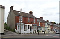
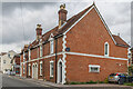
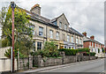
2
Ashley Road
Late 19th Century terraced housing, first marked on the 1901 25 inch map.
Image: © Ian Capper
Taken: 22 Sep 2022
0.02 miles
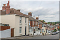
3
Kingsland Road, Salisbury
Dropping from the A360 Devizes Road to the Avon flood plain and some allotments.
Image: © Derek Harper
Taken: 30 Jun 2018
0.04 miles
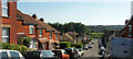
4
Devizes Road, descending into Salisbury
Image: © David Martin
Taken: 6 Mar 2022
0.04 miles
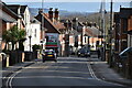
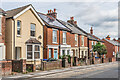
5
88 - 94 Devizes Road
Late 19th Century terrace, first marked on the 1901 25 inch map.
Image: © Ian Capper
Taken: 22 Sep 2022
0.04 miles
7
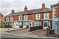
76 - 86 Devizes Road
Late 19th Century terrace, first marked on the 1901 25 inch map.
Image: © Ian Capper
Taken: 22 Sep 2022
0.05 miles
8
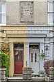
Doors and plaque, 65 - 71 Devizes Road
Front doors and plaque in the middle of the façade of 65 - 71 Devizes Road, a late 19th Century upmarket terrace, first marked on the 1901 25 inch map. See Image for a photo of the full terrace. The plaque is made up of a sunflower design with the inscription "Petros Villas 1888".
Image: © Ian Capper
Taken: 22 Sep 2022
0.05 miles
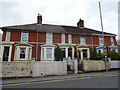
9
65 - 71 Devizes Road
Late 19th Century upmarket terrace, first marked on the 1901 25 inch map. The elaborate plaque below the central gable is made up of a sunflower design with the inscription "Petros Villas 1888". See Image for a close up.
Image: © Ian Capper
Taken: 22 Sep 2022
0.05 miles
10
Devizes Road
Early 20th Century housing, first marked on the 1926 25 inch map.
Image: © Ian Capper
Taken: 22 Sep 2022
0.06 miles