IMAGES TAKEN NEAR TO
George Street, SALISBURY, SP2 7BA
Introduction
This page details the photographs taken nearby to George Street, SP2 7BA by members of the Geograph project.
The Geograph project started in 2005 with the aim of publishing, organising and preserving representative images for every square kilometre of Great Britain, Ireland and the Isle of Man.

There are currently over 7.5m images from over14,400 individuals and you can help contribute to the project by visiting https://www.geograph.org.uk
Image Map (Loading...)


Getting Data...Please wait
Leaflet Map data © OpenStreetMap
Images are licensed for reuse under creativecommons.org/licenses/by-sa/2.0
Notes
- Clicking on the map will re-center to the selected point.
- The higher the marker number, the further away the image location is from the centre of the postcode.
Image Listing (245 Images Found)
Images are licensed for reuse under creativecommons.org/licenses/by-sa/2.0
Image
Details
Distance
1
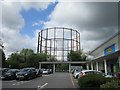
Salisbury - York Street
A view down York Street.
Image: © Chris Talbot
Taken: 17 Oct 2008
0.03 miles
2
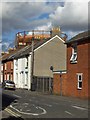
Salisbury - Middleton Road
Looking down Middleton Road towards the gasometer.
Image: © Chris Talbot
Taken: 17 Oct 2008
0.03 miles
4
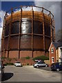
Salisbury - Gasometer
Salisbury's huge gasometer.
Image: © Chris Talbot
Taken: 17 Oct 2008
0.06 miles
5
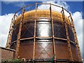
Salisbury - Gasometer
Salisbury's huge gasometer looms into the sky.
Image: © Chris Talbot
Taken: 17 Oct 2008
0.06 miles
7
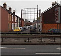
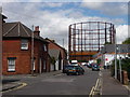
Gasholder in Salisbury
Viewed across the A36 Churchill Way West and along Middleton Road.
Image: © Jaggery
Taken: 21 Sep 2013
0.07 miles
8
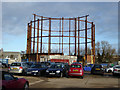
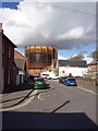
Former gasholder, Salisbury
It appears to be being dismantled.
Image: © Robin Webster
Taken: 16 Dec 2017
0.07 miles
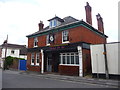
10
The Duke of York, Salisbury
Fittingly on York Road.
Image: © Robin Webster
Taken: 16 Dec 2017
0.08 miles