IMAGES TAKEN NEAR TO
Buckeridge Road, SALISBURY, SP2 0FX
Introduction
This page details the photographs taken nearby to Buckeridge Road, SP2 0FX by members of the Geograph project.
The Geograph project started in 2005 with the aim of publishing, organising and preserving representative images for every square kilometre of Great Britain, Ireland and the Isle of Man.

There are currently over 7.5m images from over14,400 individuals and you can help contribute to the project by visiting https://www.geograph.org.uk
Image Map
Images are licensed for reuse under creativecommons.org/licenses/by-sa/2.0
Notes
- Clicking on the map will re-center to the selected point.
- The higher the marker number, the further away the image location is from the centre of the postcode.
Image Listing (52 Images Found)
Images are licensed for reuse under creativecommons.org/licenses/by-sa/2.0
Image
Details
Distance
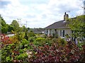
2
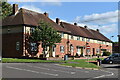
Houses and Play Area, Fugglestone
Fugglestone St Peter was an ancient parish up to 1894 when it merged with neighbouring parishes.
This picture is taken along a residential street simply called Fugglestone.
Image: © Des Blenkinsopp
Taken: 13 Aug 2024
0.13 miles
3
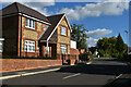
House on the corner of Oakley Road
Modern development which has borrowed many 1930s themes in the house designs.
Image: © David Martin
Taken: 8 Oct 2022
0.15 miles
4
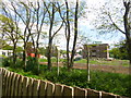
Wilton, demolition site
On The Avenue, formerly Erskine Barracks, HQ Land Command; now site of a housing development.
Image: © Mike Faherty
Taken: 15 May 2014
0.17 miles
5
Houses in Thornton Crescent
These houses appear to have been just outside the adjacent former Erskine Barracks site, that has been redeveloped as housing since 2013.
Image: © David Martin
Taken: 8 Oct 2022
0.20 miles
6
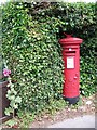
Postbox, Fugglestone St Peter
A George V postbox beside the roundabout on the A36.
Image: © Maigheach-gheal
Taken: 14 Jul 2008
0.21 miles
7
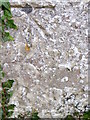
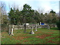
Bench Mark, St Peter's Church, Fugglestone St Peter
The bench mark is to be found on the north side of the church at the northeast angle. For a view of the church http://www.geograph.org.uk/photo/884772 and for further information on the bench mark http://www.bench-marks.org.uk/bm29806
A bench mark is an Ordnance Survey arrowhead sign found on walls, bridges, churches and specially erected triangulation pillars where the altitude above sea-level has been accurately measured by surveyors. The arrowhead points to a horizontal line above it which marks the exact altitude.
With rivets and pivots there is no datum (horizontal line) cut, the pointed-to horizontal surface defining the datum height.
Image: © Maigheach-gheal
Taken: 29 Aug 2010
0.21 miles
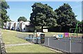
8
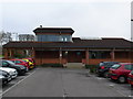
Salisbury Park and Ride
This is the main building of the park and ride which houses the waiting room and toilets. It is surrounded by car parking spaces. The buses pull up on the opposite side of this building. At time of photo the cost of a ride into Salisbury was £2.50 for a single person and £3.50 for a group of four people in a car.
Image: © Nigel Mykura
Taken: 4 Jan 2013
0.21 miles
9
A brief visit to Fugglestone St Peter (d)
Image: © Basher Eyre
Taken: 28 Dec 2013
0.21 miles
10
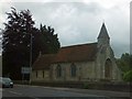
St Peter's church, Fugglestone St Peter
Image: © David Smith
Taken: 22 Jun 2013
0.21 miles