IMAGES TAKEN NEAR TO
Bailey Lane, SALISBURY, SP2 0FS
Introduction
This page details the photographs taken nearby to Bailey Lane, SP2 0FS by members of the Geograph project.
The Geograph project started in 2005 with the aim of publishing, organising and preserving representative images for every square kilometre of Great Britain, Ireland and the Isle of Man.

There are currently over 7.5m images from over14,400 individuals and you can help contribute to the project by visiting https://www.geograph.org.uk
Image Map (Loading...)


Getting Data...Please wait
Leaflet Map data © OpenStreetMap
Images are licensed for reuse under creativecommons.org/licenses/by-sa/2.0
Notes
- Clicking on the map will re-center to the selected point.
- The higher the marker number, the further away the image location is from the centre of the postcode.
Image Listing (108 Images Found)
Images are licensed for reuse under creativecommons.org/licenses/by-sa/2.0
Image
Details
Distance
1
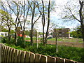
Wilton, demolition site
On The Avenue, formerly Erskine Barracks, HQ Land Command; now site of a housing development.
Image: © Mike Faherty
Taken: 15 May 2014
0.05 miles
2
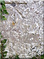
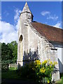
Bench Mark, St Peter's Church, Fugglestone St Peter
The bench mark is to be found on the north side of the church at the northeast angle. For a view of the church http://www.geograph.org.uk/photo/884772 and for further information on the bench mark http://www.bench-marks.org.uk/bm29806
A bench mark is an Ordnance Survey arrowhead sign found on walls, bridges, churches and specially erected triangulation pillars where the altitude above sea-level has been accurately measured by surveyors. The arrowhead points to a horizontal line above it which marks the exact altitude.
With rivets and pivots there is no datum (horizontal line) cut, the pointed-to horizontal surface defining the datum height.
Image: © Maigheach-gheal
Taken: 29 Aug 2010
0.07 miles
3
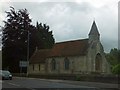
St Peter's church, Fugglestone St Peter
Image: © David Smith
Taken: 22 Jun 2013
0.07 miles
4
A brief visit to Fugglestone St Peter (d)
Image: © Basher Eyre
Taken: 28 Dec 2013
0.07 miles
5
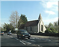
A36 passes the Church of St Peter
This little church is rather fine, being Grade II* listed. It dates from the 13th C but the bellcote was added some 200 years later. It has English Heritage Building ID: 319286 and much more detail available on: http://www.britishlistedbuildings.co.uk/en-319286-church-of-st-peter-wilton-wiltshire
Image: © Stuart Logan
Taken: 25 Apr 2013
0.07 miles
6
A brief visit to Fugglestone St Peter (a)
Image: © Basher Eyre
Taken: 28 Dec 2013
0.07 miles
7
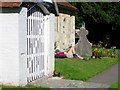
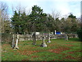
Resting in the churchyard, St Peter's Church
The walker and his cocker spaniel lie in the sunshine taking a rest. I had seen the pair sometime earlier about two miles away.
Image: © Maigheach-gheal
Taken: 29 Aug 2010
0.08 miles
8
Goldenrod (Solidago canadensis), St Peter's Church
Historically, goldenrod has been used topically for wound healing. It has also been used as a diuretic (helps rid the body of excess fluid). The name solidago means 'to make whole'.
Image: © Maigheach-gheal
Taken: 29 Aug 2010
0.08 miles
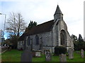
9

Wilton : St Peter's Church
St Peter's Church on Salisbury Road in Wilton.
Image: © Lewis Clarke
Taken: 28 Aug 2012
0.08 miles
10
![Wilton buildings [1]](https://s0.geograph.org.uk/geophotos/07/04/37/7043736_3cb7fd03_120x120.jpg)
Wilton buildings [1]
Once the parish church of Fugglestone, the small church of St Peter is mainly 13th century. A bellcote was added in (probably) the 15th century, and there have been alterations in phases from circa 1780 to 1900. Built in 1861, the church of St John, Bremerton, became the main church and since then St Pater has only been used for occasional services. The nave is constructed of rubble stone, the chancel is of ashlar, all under a tile roof. Listed, grade II*, with details at: https://historicengland.org.uk/listing/the-list/list-entry/1365906
A former county town, Wilton is situated some 2¾ miles west of Salisbury on the confluence of the River Nadder and the River Wylye. The town grew around Wilton Abbey, founded in the 8th century, and was the administrative capital of Wiltshire until the 11th century. The town declined in importance after Salisbury Cathedral was built. The town is renowned for carpet manufacture, which began in 1741 when two French weavers were brought in and a carpet factory continued to operate until 1995. The country estate of Wilton House is an integral part of the town.
Image: © Michael Dibb
Taken: 25 Aug 2021
0.08 miles