IMAGES TAKEN NEAR TO
Field Row, SALISBURY, SP2 0EW
Introduction
This page details the photographs taken nearby to Field Row, SP2 0EW by members of the Geograph project.
The Geograph project started in 2005 with the aim of publishing, organising and preserving representative images for every square kilometre of Great Britain, Ireland and the Isle of Man.

There are currently over 7.5m images from over14,400 individuals and you can help contribute to the project by visiting https://www.geograph.org.uk
Image Map
Images are licensed for reuse under creativecommons.org/licenses/by-sa/2.0
Notes
- Clicking on the map will re-center to the selected point.
- The higher the marker number, the further away the image location is from the centre of the postcode.
Image Listing (30 Images Found)
Images are licensed for reuse under creativecommons.org/licenses/by-sa/2.0
Image
Details
Distance
1
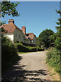
Field Row, Burcombe
A terrace of four houses on the eastern edge of the village
Image: © Derek Harper
Taken: 30 Jun 2018
0.01 miles
2
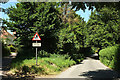
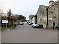
Approaching Burcombe
The lane from Bulbridge. On the left is Field Row.
Image: © Derek Harper
Taken: 30 Jun 2018
0.02 miles
3
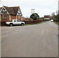
To Wilton
Looking along the road through South Burcombe on its way to Wilton. Image is on the left.
Image: © Jonathan Kington
Taken: 22 Dec 2011
0.11 miles
5
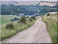
Up the byway
Looking up the byway that leads from Burcombe, up the hill past Manor Farm, to the Old Shaftesbury Drove. On the right is Manor Farm Meats, a local butcher producing their own meat (see Image by Trish Steel). There is a benchmark on the building wall just behind the white van, see Image
Image: © Jonathan Kington
Taken: 22 Dec 2011
0.15 miles
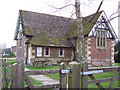
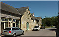
6
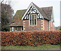
Burcombe Village Hall
Formerly a Victorian school, the village hall has recently gone through extensive renovation and modernisation.
Image: © Jonathan Kington
Taken: 22 Dec 2011
0.16 miles
7
Manor Farm, Burcombe
View of Manor Farm taken from the byway from Hunts Down.
Image: © Maigheach-gheal
Taken: 2 Aug 2007
0.16 miles
8
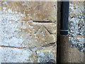
Benchmark on Manor Farm
This cut mark can be found on the former farm buildings, now used by small businesses, part way up the byway heading to Old Shaftesbury Drove. See Image for a wider view, and for more information on the mark visit http://www.bench-marks.org.uk/bm40606 .
Image: © Jonathan Kington
Taken: 22 Dec 2011
0.16 miles
9
Manor Farm, Burcombe
Restricted byway BURC3 runs alongside the converted farm buildings to the crossroads where Image] was taken.
Image: © Derek Harper
Taken: 30 Jun 2018
0.16 miles
10
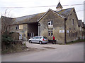
Manor Farm Meats, Burcombe
Local farm butchers.
Image: © Maigheach-gheal
Taken: 6 Feb 2007
0.16 miles