IMAGES TAKEN NEAR TO
Stratford Sub Castle, SALISBURY, SP1 3YP
Introduction
This page details the photographs taken nearby to SP1 3YP by members of the Geograph project.
The Geograph project started in 2005 with the aim of publishing, organising and preserving representative images for every square kilometre of Great Britain, Ireland and the Isle of Man.

There are currently over 7.5m images from over14,400 individuals and you can help contribute to the project by visiting https://www.geograph.org.uk
Image Map
Images are licensed for reuse under creativecommons.org/licenses/by-sa/2.0
Notes
- Clicking on the map will re-center to the selected point.
- The higher the marker number, the further away the image location is from the centre of the postcode.
Image Listing (198 Images Found)
Images are licensed for reuse under creativecommons.org/licenses/by-sa/2.0
Image
Details
Distance
1
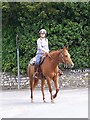
Horse and rider on Phillips Lane
The chestnut horse is fitted with a western style saddle. The horse and rider are enjoying a Sunday morning hack.
Image: © Maigheach-gheal
Taken: 6 Jun 2010
0.01 miles
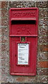
2
Elizabeth II postbox and milestone on National Cycle Route 45, Dean's Farm
Salisbury 2 1/2 Miles / Amesbuery 7 1/2 Miles.
Postbox No. SP4 11.
See Image] for postbox.
Image: © JThomas
Taken: 13 Jul 2019
0.02 miles
3
Dean's Farm, Stratford Bridge
Showing position of Postbox No. SP4 11.
See Image] for postbox.
Image: © JThomas
Taken: 13 Jul 2019
0.02 miles
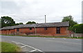
4
Dean's Farm
Farm near Stratford Bridge, now containing small business units.
Image: © Ian Capper
Taken: 22 Sep 2022
0.02 miles
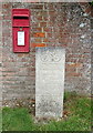
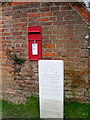
5
Elizabeth II postbox, Dean's Farm
Image: © JThomas
Taken: 13 Jul 2019
0.02 miles
6
NCN Milestone, Stratford sub Castle
National Route 45 of the National Cycle Network when finished, will connect Salisbury in Wiltshire with Chester in Cheshire, via Swindon, Cirencester, Gloucester, Worcester and Whitchurch. Here the post tells cyclists that it is 2.5 miles to Salisbury and 7.7 miles to Amesbury.
A Queen Elizabeth II postbox is set into the brick wall.
Image: © Maigheach-gheal
Taken: 1 Mar 2011
0.02 miles
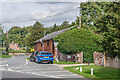
7
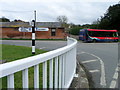
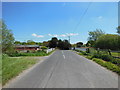
Village scene, Stratford sub Castle
The finger post tells you that the road to Salisbury is part of the Route 45 of the National Cycle Network and the Wilts and Dorset bus heads to Salisbury.
Image: © Maigheach-gheal
Taken: 1 Mar 2011
0.03 miles
8
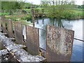
Sluices, Stratford Bridge
The sluices control the water between the two arms of the River Avon.
Image: © Maigheach-gheal
Taken: 12 May 2010
0.03 miles
10
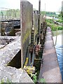
Sluices, Stratford Bridge
The sluices control the water between the two arms of the River Avon.
Image: © Maigheach-gheal
Taken: 12 May 2010
0.03 miles