IMAGES TAKEN NEAR TO
Bourne Hill, SP1 3HW
Introduction
This page details the photographs taken nearby to Bourne Hill, SP1 3HW by members of the Geograph project.
The Geograph project started in 2005 with the aim of publishing, organising and preserving representative images for every square kilometre of Great Britain, Ireland and the Isle of Man.

There are currently over 7.5m images from over14,400 individuals and you can help contribute to the project by visiting https://www.geograph.org.uk
Image Map
Images are licensed for reuse under creativecommons.org/licenses/by-sa/2.0
Notes
- Clicking on the map will re-center to the selected point.
- The higher the marker number, the further away the image location is from the centre of the postcode.
Image Listing (18 Images Found)
Images are licensed for reuse under creativecommons.org/licenses/by-sa/2.0
Image
Details
Distance
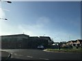
4
Car showroom by A30 in Bishopsdown
A car dealership on the northern edge of Salisbury
Image: © David Smith
Taken: 22 Jun 2013
0.11 miles
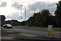
5
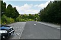
Salisbury: Entrance to the London Road Park and Ride
Image: © Michael Garlick
Taken: 29 Sep 2021
0.14 miles
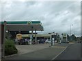
6
BMWs parked on the A30, Salisbury
Part of Marshall's large forecourt
Image: © David Howard
Taken: 20 Jun 2020
0.15 miles
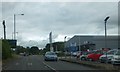
7
Welcome to Salisbury
Sign on A30 by roundabout approaching from the east
Image: © John Firth
Taken: 10 May 2010
0.16 miles
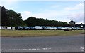
9
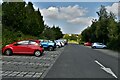
Salisbury: The London Road Park and Ride
Image: © Michael Garlick
Taken: 29 Sep 2021
0.18 miles
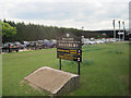
10
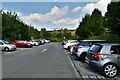
Salisbury: The London Road Park and Ride
Image: © Michael Garlick
Taken: 29 Sep 2021
0.18 miles