IMAGES TAKEN NEAR TO
St. Davids Close, SALISBURY, SP1 3FH
Introduction
This page details the photographs taken nearby to St. Davids Close, SP1 3FH by members of the Geograph project.
The Geograph project started in 2005 with the aim of publishing, organising and preserving representative images for every square kilometre of Great Britain, Ireland and the Isle of Man.

There are currently over 7.5m images from over14,400 individuals and you can help contribute to the project by visiting https://www.geograph.org.uk
Image Map
Images are licensed for reuse under creativecommons.org/licenses/by-sa/2.0
Notes
- Clicking on the map will re-center to the selected point.
- The higher the marker number, the further away the image location is from the centre of the postcode.
Image Listing (6 Images Found)
Images are licensed for reuse under creativecommons.org/licenses/by-sa/2.0
Image
Details
Distance
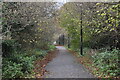
1
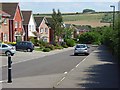
Kimpton Avenue, Hampton Park
Roads in this area of the estate are named after villages in the Andover area.
Image: © Andrew Smith
Taken: 1 Aug 2007
0.09 miles
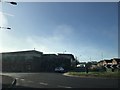
2
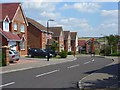
Lindford Road, Hampton Park
Part of a new estate in the north of Salisbury. This is taken at the junction with Hartley Way.
Image: © Andrew Smith
Taken: 1 Aug 2007
0.12 miles