IMAGES TAKEN NEAR TO
Linkway, SALISBURY, SP1 3EP
Introduction
This page details the photographs taken nearby to Linkway, SP1 3EP by members of the Geograph project.
The Geograph project started in 2005 with the aim of publishing, organising and preserving representative images for every square kilometre of Great Britain, Ireland and the Isle of Man.

There are currently over 7.5m images from over14,400 individuals and you can help contribute to the project by visiting https://www.geograph.org.uk
Image Map
Images are licensed for reuse under creativecommons.org/licenses/by-sa/2.0
Notes
- Clicking on the map will re-center to the selected point.
- The higher the marker number, the further away the image location is from the centre of the postcode.
Image Listing (31 Images Found)
Images are licensed for reuse under creativecommons.org/licenses/by-sa/2.0
Image
Details
Distance
1
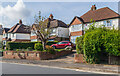
99 - 103 St Mark's Avenue
c.1930s/40s housing in St Mark's Avenue.
Image: © Ian Capper
Taken: 22 Sep 2022
0.08 miles
2
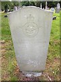
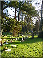
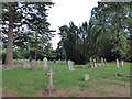
Laverstock - Cemetery
Gravestones in the London Road Cemetery.
Image: © Chris Talbot
Taken: 1 Jan 2010
0.08 miles
3
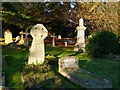
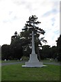
Laverstock - Cemetery
A nice obelisk gravemarker.
Image: © Chris Talbot
Taken: 1 Jan 2010
0.08 miles
4
Laverstock - Cemetery
A peaceful place to spend eternity.
Image: © Chris Talbot
Taken: 1 Jan 2010
0.08 miles
5
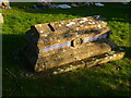
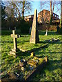
Laverstock - Cemetery
An unusual tiled tomb in the early morning sunshine.
Image: © Chris Talbot
Taken: 1 Jan 2010
0.08 miles
7
Bishopdown Road
Northward extension of St Mark's Avenue, serving the c.1960s suburb of Bishopdown.
Image: © Ian Capper
Taken: 22 Sep 2022
0.09 miles
9
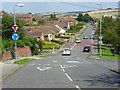
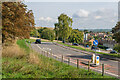
Bishopdown, Salisbury
Looking down Bishopdown Road at the junction with Denison Rise.
Image: © Andrew Smith
Taken: 1 Aug 2007
0.12 miles