IMAGES TAKEN NEAR TO
Exeter Street, SALISBURY, SP1 2SF
Introduction
This page details the photographs taken nearby to Exeter Street, SP1 2SF by members of the Geograph project.
The Geograph project started in 2005 with the aim of publishing, organising and preserving representative images for every square kilometre of Great Britain, Ireland and the Isle of Man.

There are currently over 7.5m images from over14,400 individuals and you can help contribute to the project by visiting https://www.geograph.org.uk
Image Map
Images are licensed for reuse under creativecommons.org/licenses/by-sa/2.0
Notes
- Clicking on the map will re-center to the selected point.
- The higher the marker number, the further away the image location is from the centre of the postcode.
Image Listing (1199 Images Found)
Images are licensed for reuse under creativecommons.org/licenses/by-sa/2.0
Image
Details
Distance
1
![Salisbury houses [33]](https://s2.geograph.org.uk/geophotos/06/39/46/6394690_fc098ea0_120x120.jpg)
Salisbury houses [33]
This pair of houses at numbers 111 and 112 Exeter Street is early 19th century and is listed, grade II, with details at: https://historicengland.org.uk/listing/the-list/list-entry/1023663
A cathedral was established at the Iron Age hillfort of Old Sarum by the Normans. In 1220 the cathedral was removed to the nearby plain and New Sarum (Salisbury) grew up around it, receiving a city charter in 1227. Located at the confluence of five rivers (Avon, Nadder, Ebble, Wylye and Bourne) the city is prone to flooding. Traffic between the ports of Southampton and Bristol, passes around the city's ring-road via the A36 causing much congestion.
Image: © Michael Dibb
Taken: 31 Dec 2019
0.02 miles
2
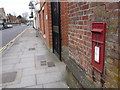
Salisbury: postbox № SP1 103, Exeter Street
Looking northward, towards the heart of the city, along Exeter Street past this Elizabeth II-reign 'lamp box', a design more readily found hugging telegraph poles or mounted on a metal post. This one is set into a wall and is emptied finally at 4:30 on weekday afternoons and at noon on Saturdays.
Image: © Chris Downer
Taken: 29 Mar 2013
0.02 miles
3
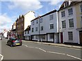
Assorted building styles in Exeter Street, Salisbury
Various styles and ages in this terrace of houses.
Image: © David Smith
Taken: 18 Oct 2016
0.02 miles
5
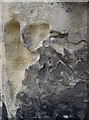
Battered benchmark
The soft stone and perhaps a few impacts have caused this cutmark to become rather damaged. See http://www.bench-marks.org.uk/bm44370 for the entry in the Benchmark Database, and Image] for a wider view.
Image: © Neil Owen
Taken: 16 May 2012
0.03 miles
6
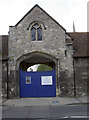
School gate
Salisbury Cathedral School has a number of entrances, this being one that leads directly onto Exeter Street. A benchmark can still just about be spotted on the righthand pillar - see Image
Image: © Neil Owen
Taken: 16 May 2012
0.03 miles
7
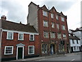
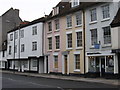
Salisbury - Exeter Street
A fine four storey in Exeter Street.
Image: © Chris Talbot
Taken: 27 Apr 2010
0.03 miles
8

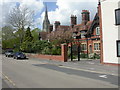
Salisbury - Bishopsgate House
Part of Bishop Wordsworth's Grammar School. The church tower belongs to St Osmunds Catholic Church.
Image: © Dave Bevis
Taken: 27 Mar 2009
0.03 miles
9
Salisbury, Brickett's Hospital
At junction Exeter Street & Carmelite Way. According to a plaque, these almshouses were originally built for 6 poor widows in 1519, and rebuilt in 1780; the present building looks at least a hundred years younger. http://www.british-history.ac.uk/report.aspx?compid=41807#s3
Image: © Mike Faherty
Taken: 25 Apr 2009
0.04 miles
10
![Salisbury houses [32]](https://s1.geograph.org.uk/geophotos/06/39/46/6394689_efa09d72_120x120.jpg)
Salisbury houses [32]
Thomas Brickett, a former mayor, built five almshouses at the junction of Exeter Street and Carmelite Way in 1534. They were rebuilt in 1780 and again in 1894. Another view of the almshouses is at Image
A cathedral was established at the Iron Age hillfort of Old Sarum by the Normans. In 1220 the cathedral was removed to the nearby plain and New Sarum (Salisbury) grew up around it, receiving a city charter in 1227. Located at the confluence of five rivers (Avon, Nadder, Ebble, Wylye and Bourne) the city is prone to flooding. Traffic between the ports of Southampton and Bristol, passes around the city's ring-road via the A36 causing much congestion.
Image: © Michael Dibb
Taken: 31 Dec 2019
0.04 miles