1
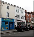
Charlie's Store and South Wilts Mencap in Salisbury
Viewed across Catherine Street. The convenience store on the left is next door to a charity shop where the sale of donated items funds the work of South Wilts Mencap, an independent local charity. Its main role is lobbying and campaigning for changes in attitudes and service provision to enable people with learning disabilities make the most of life.
Image: © Jaggery
Taken: 21 Sep 2013
0.01 miles
2
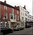
Street scene in Salisbury
Just one of the many lovely streets in the city centre.
Image: © Jeremy Bolwell
Taken: 3 Jun 2014
0.01 miles
3
Grocery & Vape, Salisbury
Grocery & Vape on Catherine Street in Salisbury. The shop sells groceries, vapes, bongs, and grinders.
Image: © Oscar Taylor
Taken: 5 Oct 2024
0.01 miles
4
The Cathedral Hotel, Salisbury
Image: © JThomas
Taken: 8 Feb 2011
0.01 miles
5
Oxfam, Salisbury
Viewed across Catherine Street. The Oxfam charity shop on the left sells donated clothes, homeware items etc. Oxfam Books and Music is on the right. There are c700 Oxfam shops in the UK and also Oxfam donation banks in many car parks. Oxfam was founded in Oxford in 1942 as the Oxford Committee for Famine Relief by a group of Quakers, social activists and Oxford academics. It changed its name to Oxfam in 1965.
Image: © Jaggery
Taken: 21 Sep 2013
0.01 miles
6
Milford Street, Salisbury
Looking east along Milford Street. The Red Lion Hotel was originally built to house draughtsmen working on the cathedral, and later became a busy coaching inn.
Image: © Peter Jordan
Taken: 14 Apr 2006
0.02 miles
7
Salisbury - Fish Row
This is one of the oldest streets in Salisbury dating back to Medieval times.
Image: © Chris Talbot
Taken: 17 Oct 2008
0.02 miles
8
Salisbury - Town Hall
This building dates from 1760 when it replaced a Tudor building which burnt down.
Image: © Chris Talbot
Taken: 17 Oct 2008
0.02 miles
9
Salisbury - Red Lion Hotel
The Red Lion Hotel in Milton street.
Image: © Chris Talbot
Taken: 1 Jan 2010
0.02 miles
10
Salisbury - Red Lion Hotel
Courtyard of the Red Lion Hotel.
Image: © Chris Talbot
Taken: 1 Jan 2010
0.02 miles


