IMAGES TAKEN NEAR TO
Clanville, ANDOVER, SP11 9JE
Introduction
This page details the photographs taken nearby to SP11 9JE by members of the Geograph project.
The Geograph project started in 2005 with the aim of publishing, organising and preserving representative images for every square kilometre of Great Britain, Ireland and the Isle of Man.

There are currently over 7.5m images from over14,400 individuals and you can help contribute to the project by visiting https://www.geograph.org.uk
Image Map
Images are licensed for reuse under creativecommons.org/licenses/by-sa/2.0
Notes
- Clicking on the map will re-center to the selected point.
- The higher the marker number, the further away the image location is from the centre of the postcode.
Image Listing (4 Images Found)
Images are licensed for reuse under creativecommons.org/licenses/by-sa/2.0
Image
Details
Distance
1
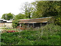
Clanville - Red House Farm
Part of Red House Farm.
Image: © Chris Talbot
Taken: 5 May 2008
0.04 miles
2
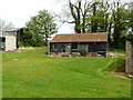
Clanville - Red House Farm
This building seems to have some age to it and has what seem to be a satellite
dish mounted on it, I just liked the mix of the old and the new.
Image: © Chris Talbot
Taken: 5 May 2008
0.04 miles
3
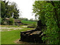
Clanville - Red House Farm
Part of the farm yard.
Image: © Chris Talbot
Taken: 5 May 2008
0.04 miles
4
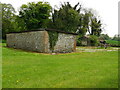
Clanville - Red House Farm
A flint and brick storage shed.
Image: © Chris Talbot
Taken: 5 May 2008
0.04 miles