IMAGES TAKEN NEAR TO
Palestine, ANDOVER, SP11 7EN
Introduction
This page details the photographs taken nearby to SP11 7EN by members of the Geograph project.
The Geograph project started in 2005 with the aim of publishing, organising and preserving representative images for every square kilometre of Great Britain, Ireland and the Isle of Man.

There are currently over 7.5m images from over14,400 individuals and you can help contribute to the project by visiting https://www.geograph.org.uk
Image Map
Images are licensed for reuse under creativecommons.org/licenses/by-sa/2.0
Notes
- Clicking on the map will re-center to the selected point.
- The higher the marker number, the further away the image location is from the centre of the postcode.
Image Listing (18 Images Found)
Images are licensed for reuse under creativecommons.org/licenses/by-sa/2.0
Image
Details
Distance
1
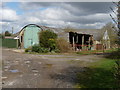
Palestine - Esher Farm
Esher Farm as seen from Zion Road.
Image: © Chris Talbot
Taken: 4 Apr 2010
0.02 miles
2
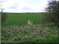
Palestine - MOD Danger Area
Although its farmed this MOD land is out of bounds to the public.
Image: © Chris Talbot
Taken: 4 Apr 2010
0.07 miles
3
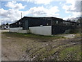
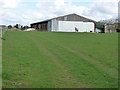
Palestine - Cherry Tree Farm
The poultry unit of Cherry Tree Farm on Zion Road.
Image: © Chris Talbot
Taken: 4 Apr 2010
0.07 miles
4
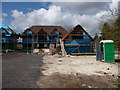
Palestine - New Houses
New houses under construction adjacent to Cherry Tree Farm.
Image: © Chris Talbot
Taken: 4 Apr 2010
0.07 miles
5
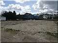
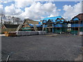
Palestine - Building Site
New houses being built on Mount Hermon Road.
Image: © Chris Talbot
Taken: 4 Apr 2010
0.07 miles
6
Palestine - Building Site
New houses being built on Mount Hermon Road.
Image: © Chris Talbot
Taken: 4 Apr 2010
0.07 miles
7
Palestine - Esher Farm
Part of Esher Farm as seen from Zion Road.
Image: © Chris Talbot
Taken: 4 Apr 2010
0.10 miles
8
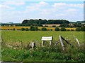
Zion Road, Palestine
Viewed facing north west towards open country. Palestine was developed after the Great War to provide accommodation and a living for demobilised soldiers returning from the near East. It never quite succeeded. The name Zion Road perpetuates the link with that ever-sensitive region.
Image: © Brian Robert Marshall
Taken: 11 Jul 2007
0.11 miles
9
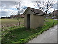
Palestine - Bus Stop
A rather small and bunker like bus stop.
Image: © Chris Talbot
Taken: 4 Apr 2010
0.13 miles
10
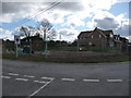
Palestine - Building Site
A new house under construction on the junction of Mount Harmon Road and Streetway Road.
Image: © Chris Talbot
Taken: 4 Apr 2010
0.13 miles