IMAGES TAKEN NEAR TO
Picket Piece, ANDOVER, SP11 6NA
Introduction
This page details the photographs taken nearby to SP11 6NA by members of the Geograph project.
The Geograph project started in 2005 with the aim of publishing, organising and preserving representative images for every square kilometre of Great Britain, Ireland and the Isle of Man.

There are currently over 7.5m images from over14,400 individuals and you can help contribute to the project by visiting https://www.geograph.org.uk
Image Map (Loading...)


Getting Data...Please wait
Leaflet Map data © OpenStreetMap
Images are licensed for reuse under creativecommons.org/licenses/by-sa/2.0
Notes
- Clicking on the map will re-center to the selected point.
- The higher the marker number, the further away the image location is from the centre of the postcode.
Image Listing (2 Images Found)
Images are licensed for reuse under creativecommons.org/licenses/by-sa/2.0
Image
Details
Distance
1
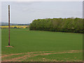
Farmland, Apsley
A field to the east of the dismantled railway that crosses the grid-square.
Image: © Andrew Smith
Taken: 6 May 2007
0.23 miles
2
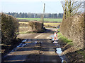
Badly pot-holed lane
Not typical of the rest of the lane, just this stretch suffered somewhat before meeting the main road.
Image: © Robin Webster
Taken: 13 Feb 2017
0.24 miles