IMAGES TAKEN NEAR TO
St. Mary Bourne, ANDOVER, SP11 6EF
Introduction
This page details the photographs taken nearby to SP11 6EF by members of the Geograph project.
The Geograph project started in 2005 with the aim of publishing, organising and preserving representative images for every square kilometre of Great Britain, Ireland and the Isle of Man.

There are currently over 7.5m images from over14,400 individuals and you can help contribute to the project by visiting https://www.geograph.org.uk
Image Map
Images are licensed for reuse under creativecommons.org/licenses/by-sa/2.0
Notes
- Clicking on the map will re-center to the selected point.
- The higher the marker number, the further away the image location is from the centre of the postcode.
Image Listing (9 Images Found)
Images are licensed for reuse under creativecommons.org/licenses/by-sa/2.0
Image
Details
Distance
1
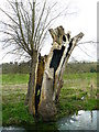
Stoke - Split Willow
This tree seems to have been struck by lightning.
Image: © Chris Talbot
Taken: 16 Apr 2008
0.15 miles
2
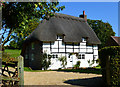
Myrtle Cottage, St Mary Bourne, Hampshire
C18. One storey and attic, 2 windows at the ground floor. Thatched roof, hipped at the west end, half-hipped at the east. The timber frame is exposed mainly in the upper part, bricknogged; other walling is of flint with brick quoins. Small casements. Boarded door in solid frame.
(Source:Historic England)
Image: © Oswald Bertram
Taken: 2 Oct 2015
0.20 miles
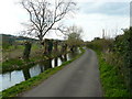
3
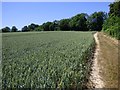
Farmland, St Mary Bourne
The Test Way and Brenda Parker Way climbing towards Stokehill.
Image: © Andrew Smith
Taken: 30 Jun 2018
0.20 miles
4
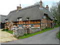
Stoke - Butlers Farm
This converted farm house shows a brick and timber construction.
Image: © Chris Talbot
Taken: 16 Apr 2008
0.20 miles
5
Stoke - Butlers Farm
These thatched barns are found at the rear of Butlers Farm.
Image: © Chris Talbot
Taken: 16 Apr 2008
0.20 miles
6
Stoke - Pollarded Willows
These willows growing alongside the River Bourne have been cut back to encourage new growth.
Image: © Chris Talbot
Taken: 16 Apr 2008
0.20 miles
7
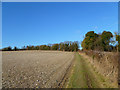
Farmland, St Mary Bourne
The Test Way footpath climbing beside a ploughed field.
Image: © Andrew Smith
Taken: 30 Jan 2011
0.22 miles
8
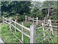
Village Pound
A village pound, once used for escaped farm animals. Owners would pay a fee to have the animal returned. Looks like the area was cleared recently.
This one is in what was once the hamlet of Swampton, now considered to just be part of Saint Mary Bourne.
Image: © Carmen
Taken: 6 Aug 2020
0.23 miles
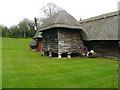
9
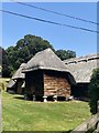
Traditional Staddlestone Barn or Granary
Very rare to see these wooden, with thatch and on staddle stones. Probably late mediaeval but rebuilt or refurbished. Traditionally elevated to protect against rats. Note also the long thatch, characteristic of the area.
Image: © Carmen
Taken: 6 Aug 2020
0.24 miles