IMAGES TAKEN NEAR TO
Vernham Row, ANDOVER, SP11 0LH
Introduction
This page details the photographs taken nearby to Vernham Row, SP11 0LH by members of the Geograph project.
The Geograph project started in 2005 with the aim of publishing, organising and preserving representative images for every square kilometre of Great Britain, Ireland and the Isle of Man.

There are currently over 7.5m images from over14,400 individuals and you can help contribute to the project by visiting https://www.geograph.org.uk
Image Map
Images are licensed for reuse under creativecommons.org/licenses/by-sa/2.0
Notes
- Clicking on the map will re-center to the selected point.
- The higher the marker number, the further away the image location is from the centre of the postcode.
Image Listing (3 Images Found)
Images are licensed for reuse under creativecommons.org/licenses/by-sa/2.0
Image
Details
Distance
1
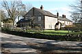
Vernham Row
Stone houses on Bower's Lane, south of Church Lane.
Image: © Brendan and Ruth McCartney
Taken: 19 Mar 2012
0.01 miles
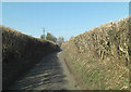
3

Track leading west from Vernham Row
Formerly defined as a Restricted Byway, but now classified as an "Other route with public access".
Image: © David Purchase
Taken: 11 Jul 2012
0.08 miles