IMAGES TAKEN NEAR TO
Leyton Way, ANDOVER, SP10 2UJ
Introduction
This page details the photographs taken nearby to Leyton Way, SP10 2UJ by members of the Geograph project.
The Geograph project started in 2005 with the aim of publishing, organising and preserving representative images for every square kilometre of Great Britain, Ireland and the Isle of Man.

There are currently over 7.5m images from over14,400 individuals and you can help contribute to the project by visiting https://www.geograph.org.uk
Image Map
Images are licensed for reuse under creativecommons.org/licenses/by-sa/2.0
Notes
- Clicking on the map will re-center to the selected point.
- The higher the marker number, the further away the image location is from the centre of the postcode.
Image Listing (50 Images Found)
Images are licensed for reuse under creativecommons.org/licenses/by-sa/2.0
Image
Details
Distance
1
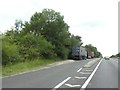
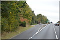
Lay-by for westbound traffic, A303 Andover bypass
Image: © David Smith
Taken: 9 Jul 2019
0.05 miles
2
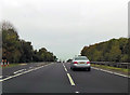
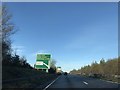
A303 at lay by
Just west of river crossing
Image: © John Firth
Taken: 23 Oct 2015
0.06 miles
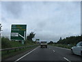
6
Signage on A303 - Salisbury to the left
Image: © Dave Thompson
Taken: 18 Jan 2020
0.09 miles
7
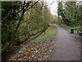
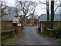
Upper Clatford - Footpath
This path leeds from Upper Clatford into Andover
Image: © Chris Talbot
Taken: 11 Dec 2010
0.10 miles
8
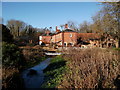
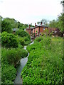
Upper Clatford - Rooksbury Mill
This former watermill has been converted into a house.
Image: © Chris Talbot
Taken: 3 Jan 2010
0.10 miles
9
Upper Clatford - Rooksbury Mill
This old water mill has recently be converted into a dwelling.
Image: © Chris Talbot
Taken: 25 May 2009
0.10 miles
10
Upper Clatford - Rooksbury Mill
This used to be a working mill that has been converted into housing.
Image: © Chris Talbot
Taken: 11 Dec 2010
0.10 miles