IMAGES TAKEN NEAR TO
Borsberry Close, ANDOVER, SP10 1HZ
Introduction
This page details the photographs taken nearby to Borsberry Close, SP10 1HZ by members of the Geograph project.
The Geograph project started in 2005 with the aim of publishing, organising and preserving representative images for every square kilometre of Great Britain, Ireland and the Isle of Man.

There are currently over 7.5m images from over14,400 individuals and you can help contribute to the project by visiting https://www.geograph.org.uk
Image Map
Images are licensed for reuse under creativecommons.org/licenses/by-sa/2.0
Notes
- Clicking on the map will re-center to the selected point.
- The higher the marker number, the further away the image location is from the centre of the postcode.
Image Listing (99 Images Found)
Images are licensed for reuse under creativecommons.org/licenses/by-sa/2.0
Image
Details
Distance
1
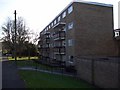
Andover - Flats
These flats border the edge of Acre Court.
Image: © Chris Talbot
Taken: 25 Nov 2008
0.07 miles
4
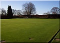
Andover - Bowling Green
This green belongs to Andover Bowling Club which as established in 1913.
Image: © Chris Talbot
Taken: 25 Nov 2008
0.09 miles
5
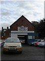
Andover - A.J. Motors
This motor sales and service establishment was founded in 1957.
Image: © Chris Talbot
Taken: 3 Oct 2009
0.11 miles
6
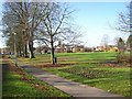
Andover - Recreation Ground
A view across the recreation ground towards the town centre.
Image: © Chris Talbot
Taken: 25 Nov 2008
0.11 miles
7
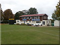
Andover - Andover Cricket Club
The Andover Cricket Club pavilion is located in London Road.
Image: © Chris Talbot
Taken: 3 Oct 2009
0.11 miles
8
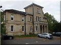
Andover - Eastfield House
This building used to be a home for the blind and after that a home for the elderly, it has now been converted into flats.
Image: © Chris Talbot
Taken: 3 Oct 2009
0.13 miles
10
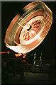
Andover - Wall Of Death
This was taken at the last fair on the walled meadow before it was built on and became a housing estate in 1989.
Image: © Chris Talbot
Taken: 24 Sep 1988
0.16 miles