IMAGES TAKEN NEAR TO
SO9 7ZQ
Introduction
This page details the photographs taken nearby to SO9 7ZQ by members of the Geograph project.
The Geograph project started in 2005 with the aim of publishing, organising and preserving representative images for every square kilometre of Great Britain, Ireland and the Isle of Man.

There are currently over 7.5m images from over14,400 individuals and you can help contribute to the project by visiting https://www.geograph.org.uk
Image Map
Images are licensed for reuse under creativecommons.org/licenses/by-sa/2.0
Notes
- Clicking on the map will re-center to the selected point.
- The higher the marker number, the further away the image location is from the centre of the postcode.
Image Listing (131 Images Found)
Images are licensed for reuse under creativecommons.org/licenses/by-sa/2.0
Image
Details
Distance
1
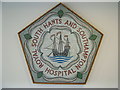
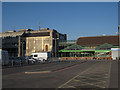
Mosaic, Royal South Hants & Southampton Hospital
An interesting mosaic on a wall inside the hospital.
Image: © Rob Candlish
Taken: 28 Jul 2010
0.05 miles
2
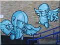
Artwork, Newtown Youth Centre, Graham Road
Image: © Alex McGregor
Taken: 26 Mar 2012
0.08 miles
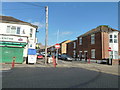
3
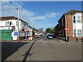
Looking from Derby Road into Clovelly Road
Image: © Basher Eyre
Taken: 23 Jun 2011
0.08 miles
5
Chapel at Royal South Hants Hospital
Part of the complex that offers a variety of services, but doesn't have an Accident and Emergency unit.
Image: © Hugh Venables
Taken: 14 May 2010
0.09 miles
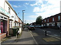
10
Upturned shopping trolley in Durnford Road
Image: © Basher Eyre
Taken: 23 Jun 2011
0.10 miles