IMAGES TAKEN NEAR TO
SO5 8RR
Introduction
This page details the photographs taken nearby to SO5 8RR by members of the Geograph project.
The Geograph project started in 2005 with the aim of publishing, organising and preserving representative images for every square kilometre of Great Britain, Ireland and the Isle of Man.

There are currently over 7.5m images from over14,400 individuals and you can help contribute to the project by visiting https://www.geograph.org.uk
Image Map
Images are licensed for reuse under creativecommons.org/licenses/by-sa/2.0
Notes
- Clicking on the map will re-center to the selected point.
- The higher the marker number, the further away the image location is from the centre of the postcode.
Image Listing (11 Images Found)
Images are licensed for reuse under creativecommons.org/licenses/by-sa/2.0
Image
Details
Distance
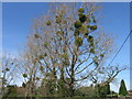
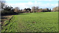
3
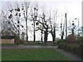
Road junction with mistletoe on the Botley Road
The junction of the Botley Road and Whitenap Lane. There is mistletoe here every year on these trees on the corner of the Whitenap recreation area, but not usually in such profusion.
Image: © Rosemary Oakeshott
Taken: 9 Dec 2007
0.13 miles
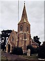
8
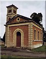
Romsey Nonconformist Cemetery Chapel
Grade 2 listed building erected in 1850.
Image: © Michael FORD
Taken: Unknown
0.22 miles
9
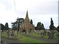
Cemetery Chapel, Romsey
The Anglican chapel in Botley Road cemetery. A Gothic style chapel built in circa 1850 it is now used as a heritage and architectural salvage store.
Image: © Rosemary Oakeshott
Taken: 9 Dec 2007
0.22 miles
10
Romsey Anglican Cemetery Chapel
Erected in 1850.
Image: © Michael FORD
Taken: Unknown
0.22 miles