IMAGES TAKEN NEAR TO
Kingsway, EASTLEIGH, SO53 5DR
Introduction
This page details the photographs taken nearby to Kingsway, SO53 5DR by members of the Geograph project.
The Geograph project started in 2005 with the aim of publishing, organising and preserving representative images for every square kilometre of Great Britain, Ireland and the Isle of Man.

There are currently over 7.5m images from over14,400 individuals and you can help contribute to the project by visiting https://www.geograph.org.uk
Image Map
Images are licensed for reuse under creativecommons.org/licenses/by-sa/2.0
Notes
- Clicking on the map will re-center to the selected point.
- The higher the marker number, the further away the image location is from the centre of the postcode.
Image Listing (26 Images Found)
Images are licensed for reuse under creativecommons.org/licenses/by-sa/2.0
Image
Details
Distance
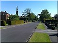
1
Thornbury Wood, no through road
The spine road of a small housing estate on the east side of Kingsway, Hiltingbury.
Image: © Christine Johnstone
Taken: 8 Nov 2021
0.02 miles
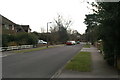
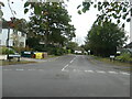
2
Junction of Kingsway and Grosvenor Road, Hiltingbury
There is a 56 metre spot height at the manhole cover.
Image: © Christine Johnstone
Taken: 8 Nov 2021
0.03 miles
3
Malibres Road, Hiltingbury
Planned and mapped in the 1930s, but no houses were built until after 1945. Named after Malibres Copse, which it was built on.
Image: © Christine Johnstone
Taken: 8 Nov 2021
0.03 miles
4
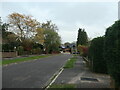
East end of Grosvenor Road, Hiltingbury
Planned and mapped in the 1930s, but no houses were built until after 1945. Looking towards the junction with Kingsway.
Image: © Christine Johnstone
Taken: 8 Nov 2021
0.05 miles
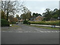
5
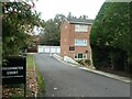
Entrance to Freshwater Court, Hiltingbury
And also the access to a house behind the flats.
Image: © Christine Johnstone
Taken: 8 Nov 2021
0.11 miles
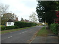
6
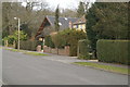
Marlborough Road, Hiltingbury
A street of large detached houses in Hiltingbury
Image: © Pierre Terre
Taken: 20 Mar 2006
0.13 miles
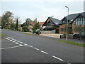
7
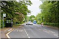
Winchester Road, Chandler's Ford
The blue bus is parked at the entrance to Thornden and Lakeside Schools.
Image: © Peter Facey
Taken: 9 May 2008
0.14 miles
8
West end of Grosvenor Road, Hiltingbury
Planned and mapped in the 1930s, but no houses were built until after 1945. Near the junction with Thorold Road.
Image: © Christine Johnstone
Taken: 8 Nov 2021
0.16 miles