IMAGES TAKEN NEAR TO
Rownhams Lane, SOUTHAMPTON, SO52 9LP
Introduction
This page details the photographs taken nearby to Rownhams Lane, SO52 9LP by members of the Geograph project.
The Geograph project started in 2005 with the aim of publishing, organising and preserving representative images for every square kilometre of Great Britain, Ireland and the Isle of Man.

There are currently over 7.5m images from over14,400 individuals and you can help contribute to the project by visiting https://www.geograph.org.uk
Image Map (Loading...)


Getting Data...Please wait
Leaflet Map data © OpenStreetMap
Images are licensed for reuse under creativecommons.org/licenses/by-sa/2.0
Notes
- Clicking on the map will re-center to the selected point.
- The higher the marker number, the further away the image location is from the centre of the postcode.
Image Listing (11 Images Found)
Images are licensed for reuse under creativecommons.org/licenses/by-sa/2.0
Image
Details
Distance
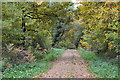
6
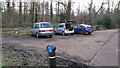
Parking for Rownhams Wood walk
A small area to park cars by the entrance to the forestry commission land known as Rownhams Wood.
Image: © J W Parker
Taken: 1 Mar 2014
0.18 miles
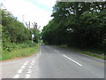
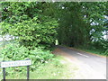
8
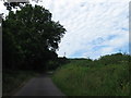
Rownhams Lane
Rownhams Lane passing Packridge Lane
Image: © Shaun Ferguson
Taken: 30 Jan 2013
0.22 miles
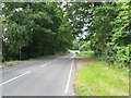
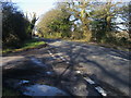
10
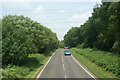
Rownhams Lane
Heading north, viewed from top deck of a bus.
Image: © Pierre Terre
Taken: 28 Jun 2006
0.23 miles