IMAGES TAKEN NEAR TO
Copse Close, SOUTHAMPTON, SO52 9HD
Introduction
This page details the photographs taken nearby to Copse Close, SO52 9HD by members of the Geograph project.
The Geograph project started in 2005 with the aim of publishing, organising and preserving representative images for every square kilometre of Great Britain, Ireland and the Isle of Man.

There are currently over 7.5m images from over14,400 individuals and you can help contribute to the project by visiting https://www.geograph.org.uk
Image Map
Images are licensed for reuse under creativecommons.org/licenses/by-sa/2.0
Notes
- Clicking on the map will re-center to the selected point.
- The higher the marker number, the further away the image location is from the centre of the postcode.
Image Listing (13 Images Found)
Images are licensed for reuse under creativecommons.org/licenses/by-sa/2.0
Image
Details
Distance
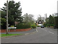
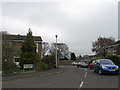
2
Rownhams Lane, North Baddesley
Somewhat south of Dunnings Lane. Map reference slightly uncertain.
Image: © Peter Facey
Taken: 2 May 2008
0.11 miles
3
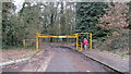
Entrance to Mountbatten Park
This is the entrance to Mountbatten Park, which has a lovely little wooded walk and a small field.
Image: © J W Parker
Taken: 28 Feb 2014
0.13 miles
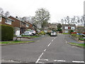
5
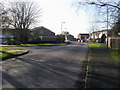
Sylvan Drive
Sylvan Drive heading to Ringwood Drive
Image: © Shaun Ferguson
Taken: 30 Jan 2013
0.15 miles
6
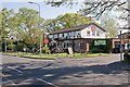
Bedes Lea pub, Rownhams Lane, North Baddesley
Operated by Gusto Inns.
Image: © Peter Facey
Taken: 2 May 2008
0.15 miles
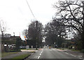
7
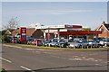
Kingslake Cars and North Baddesley Service Centre
On the corner of Rownhams Road and Firgrove Road. Including a Murco filling station.
Image: © Peter Facey
Taken: 2 May 2008
0.16 miles
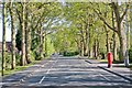
8
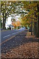
Autumn leaves on Rownhams Lane, North Baddesley
Image: © David Martin
Taken: 7 Nov 2018
0.16 miles