IMAGES TAKEN NEAR TO
Cedar Crescent, SOUTHAMPTON, SO52 9FX
Introduction
This page details the photographs taken nearby to Cedar Crescent, SO52 9FX by members of the Geograph project.
The Geograph project started in 2005 with the aim of publishing, organising and preserving representative images for every square kilometre of Great Britain, Ireland and the Isle of Man.

There are currently over 7.5m images from over14,400 individuals and you can help contribute to the project by visiting https://www.geograph.org.uk
Image Map
Images are licensed for reuse under creativecommons.org/licenses/by-sa/2.0
Notes
- Clicking on the map will re-center to the selected point.
- The higher the marker number, the further away the image location is from the centre of the postcode.
Image Listing (18 Images Found)
Images are licensed for reuse under creativecommons.org/licenses/by-sa/2.0
Image
Details
Distance
1
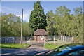
Southern Water station on Botley Road, North Baddesley
Possibly a small pumping station. It incorporates an electricity substation.
Image: © Peter Facey
Taken: 2 May 2008
0.06 miles
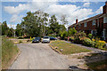
2
Baddesley Close
A residential cul de sac off Botley Road.
Image: © Peter Facey
Taken: 3 Jul 2010
0.09 miles
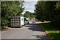
3
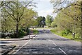
A27 Botley Road approaches Scragg Hill, North Baddesley
The crossing in foreground affords pedestrian access to Baddesley Close.
Image: © Peter Facey
Taken: 2 May 2008
0.10 miles
4
Baddesley Close
The close has two arms and this is the eastern one.
Image: © Peter Facey
Taken: 3 Jul 2010
0.11 miles
5
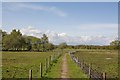
Footpath approaching Baddesley Common
The footpath runs from the A27 at North Baddesley across the common to Emer Farm.
Image: © Peter Facey
Taken: 2 May 2008
0.18 miles
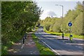
6
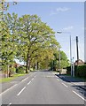
Rownhams Lane, North Baddesley
From just north of St Andrew's Close (turning on right).
Image: © Peter Facey
Taken: 2 May 2008
0.18 miles
7
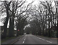
Tree lined Rownhams Lane
From Dunnings Lane
Image: © John Firth
Taken: 14 Apr 2013
0.18 miles
8
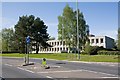
Roman House at Test Valley Business Park, North Baddesley
This office building is empty. It was formerly occupied by NHS Shared Business Services which has moved to Compass House on the Ordnance Survey site in Southampton.
Image: © Peter Facey
Taken: 2 May 2008
0.18 miles
9
Looking along A27 Botley Road, North Baddesley
Firgrove Road is in foreground left. The quite striking building in the distance behind the trees is Image
Image: © Peter Facey
Taken: 2 May 2008
0.19 miles
10
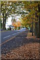
Autumn leaves on Rownhams Lane, North Baddesley
Image: © David Martin
Taken: 7 Nov 2018
0.20 miles