IMAGES TAKEN NEAR TO
Bracken Road, SOUTHAMPTON, SO52 9FP
Introduction
This page details the photographs taken nearby to Bracken Road, SO52 9FP by members of the Geograph project.
The Geograph project started in 2005 with the aim of publishing, organising and preserving representative images for every square kilometre of Great Britain, Ireland and the Isle of Man.

There are currently over 7.5m images from over14,400 individuals and you can help contribute to the project by visiting https://www.geograph.org.uk
Image Map
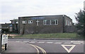
Images are licensed for reuse under creativecommons.org/licenses/by-sa/2.0
Notes
- Clicking on the map will re-center to the selected point.
- The higher the marker number, the further away the image location is from the centre of the postcode.
Image Listing (22 Images Found)
Images are licensed for reuse under creativecommons.org/licenses/by-sa/2.0
Image
Details
Distance
1
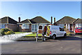
Flushing the water main
Water running to waste to clean out the water main here. So said the man when asked.
Image: © Robin Webster
Taken: 7 Feb 2017
0.11 miles
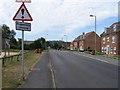
3
Rownhams Road, North Baddesley
Looking along it from its western end.
Image: © Peter Facey
Taken: 2 May 2008
0.13 miles
4
Fleming Avenue joins Rownhams Road, North Baddesley
Fleming Avenue is a very large semicircle, both ends of which are on Rownhams Road. This is the southern end.
Image: © Peter Facey
Taken: 2 May 2008
0.14 miles
5
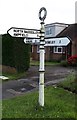
Old Direction Sign - Signpost by Rownhams Lane, North Baddesley
Annulus finial - 3 arms; Hampshire Parish halo by the UC road, in parish of North Baddesley (Test Valley District), junction of Rownhams Lane with Rownhams Road, in front garden.
To be surveyed
Milestone Society National ID: HA_SU3919
Image: © Milestone Society
Taken: Unknown
0.16 miles
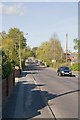
6
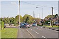
Junction of Rownhams Lane and Rownhams Road
Road is on left; Lane behind and ahead.
Image: © Peter Facey
Taken: 2 May 2008
0.17 miles
7
Bend in Thomas Road
This whole area used to be the site of Borden Chemicals. Straight ahead used to be the main gates to the site and to the left was the car park. The whole site was razed to the ground about 2003 and houses built on it.
Image: © John Firth
Taken: 14 Apr 2013
0.18 miles
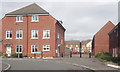
8
Borden Way, North Baddesley
This newly built housing is off Rownhams Road. It is not yet on any map. The map reference may need adjusting when maps become available.
Image: © Peter Facey
Taken: 2 May 2008
0.20 miles
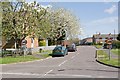
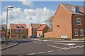
10
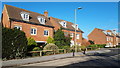
Modern housing in Rownhams Road
As is often the case, these houses were the last ones in the development, built on the green space in front of the showhomes in around 2006 - the street scene has now matured.
Image: © David Martin
Taken: 20 Jan 2019
0.20 miles