IMAGES TAKEN NEAR TO
Nutburn Road, SOUTHAMPTON, SO52 9DZ
Introduction
This page details the photographs taken nearby to Nutburn Road, SO52 9DZ by members of the Geograph project.
The Geograph project started in 2005 with the aim of publishing, organising and preserving representative images for every square kilometre of Great Britain, Ireland and the Isle of Man.

There are currently over 7.5m images from over14,400 individuals and you can help contribute to the project by visiting https://www.geograph.org.uk
Image Map
Images are licensed for reuse under creativecommons.org/licenses/by-sa/2.0
Notes
- Clicking on the map will re-center to the selected point.
- The higher the marker number, the further away the image location is from the centre of the postcode.
Image Listing (43 Images Found)
Images are licensed for reuse under creativecommons.org/licenses/by-sa/2.0
Image
Details
Distance
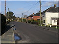
1
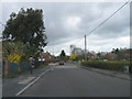
Nutburn Road, North Baddesley
A residential area
Image: © Alex McGregor
Taken: 31 Mar 2010
0.02 miles
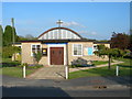
3
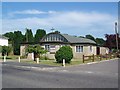
Baptist Church, North Baddesley
The church is on Nutburn Road.
Image: © Maigheach-gheal
Taken: 1 Jul 2008
0.04 miles
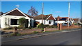
4
North Baddesley Baptist Church
At Nutburn.
Image: © Michael FORD
Taken: Unknown
0.04 miles
5
Nutburn Road
Nutburn Road heading to Bucket Corner
Image: © Shaun Ferguson
Taken: 30 Jan 2013
0.04 miles
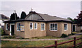
6
Baptist Church
Prefabricated Baptist Church in Pound Lane North Baddesley.
Image: © Jim Goldsmith
Taken: 3 May 2006
0.06 miles
7
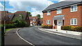
Knights Meadows
Modern housing estate built on Image
Image: © David Martin
Taken: 17 May 2021
0.07 miles
8
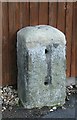
Old Milestone by the A27, Botley Road, North Baddesley
Metal plate attached to stone post by the A27, in parish of NORTH BADDESLEY (TEST VALLEY District), Brown Hill; by No. 129 Botley Road, opposite 'Knights Cross' PH, by the road, on East side of road. Botley plate, erected by the Botley turnpike trust in the 19th century.
Inscription once read:-
(ROMSEY)
(3)
(BOTLEY)
(9)
Milestone Society National ID: HA_BORO09.
Image: © K Lawrence
Taken: 26 May 2003
0.07 miles
9
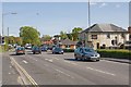
Crossroads on A27 at North Baddesley
A27 Botley Road behind and ahead; Nutburn Road left; Rownhams Road right. The Knights Cross pub at right.
Image: © Peter Facey
Taken: 2 May 2008
0.07 miles
10
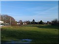
Field at North Baddesley
Usually home to some ponies.
Image: © David Martin
Taken: 22 Dec 2011
0.08 miles