IMAGES TAKEN NEAR TO
Botley Road, SOUTHAMPTON, SO52 9DQ
Introduction
This page details the photographs taken nearby to Botley Road, SO52 9DQ by members of the Geograph project.
The Geograph project started in 2005 with the aim of publishing, organising and preserving representative images for every square kilometre of Great Britain, Ireland and the Isle of Man.

There are currently over 7.5m images from over14,400 individuals and you can help contribute to the project by visiting https://www.geograph.org.uk
Image Map
Images are licensed for reuse under creativecommons.org/licenses/by-sa/2.0
Notes
- Clicking on the map will re-center to the selected point.
- The higher the marker number, the further away the image location is from the centre of the postcode.
Image Listing (14 Images Found)
Images are licensed for reuse under creativecommons.org/licenses/by-sa/2.0
Image
Details
Distance
1
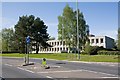
Roman House at Test Valley Business Park, North Baddesley
This office building is empty. It was formerly occupied by NHS Shared Business Services which has moved to Compass House on the Ordnance Survey site in Southampton.
Image: © Peter Facey
Taken: 2 May 2008
0.06 miles
2
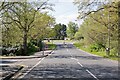
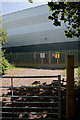
Looking along A27 Botley Road, North Baddesley
Firgrove Road is in foreground left. The quite striking building in the distance behind the trees is Image
Image: © Peter Facey
Taken: 2 May 2008
0.06 miles
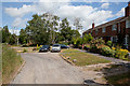
3
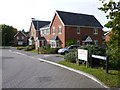
Baddesley Close
A residential cul de sac off Botley Road.
Image: © Peter Facey
Taken: 3 Jul 2010
0.10 miles
4
Baddesley Close
The close has two arms and this is the eastern one.
Image: © Peter Facey
Taken: 3 Jul 2010
0.10 miles
5
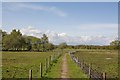
Footpath approaching Baddesley Common
The footpath runs from the A27 at North Baddesley across the common to Emer Farm.
Image: © Peter Facey
Taken: 2 May 2008
0.11 miles
6
Ashfield View North Baddesley
Ashfield View is a "select" modern residential development which clearly states Private No Parking. It is just off the A27 Botley Rd at North Baddesley.
Image: © Nigel Mykura
Taken: 26 Oct 2009
0.12 miles
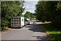
7
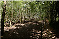
Footpath and woodland beside Test Valley Business Park
The woodland on the left is flooded in winter.
Image: © Peter Facey
Taken: 3 Jul 2010
0.14 miles
8
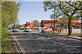
Total Filling Station on A27 at North Baddesley
Just south of its junction with Firgrove Road.
Image: © Peter Facey
Taken: 2 May 2008
0.14 miles
9
Draper Tools building in Test Valley Business Park
Recently built on this land http://www.geograph.org.uk/photo/789799 .
Image: © Peter Facey
Taken: 3 Jul 2010
0.14 miles
10
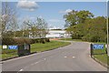
Draper Tools within Test Valley Business Park, North Baddelsey
This shows the main entrance to the park which is somewhat embryonic, since only Draper Tools' building is there.
Image: © Peter Facey
Taken: 2 May 2008
0.15 miles