IMAGES TAKEN NEAR TO
SO51 9YD
Introduction
This page details the photographs taken nearby to SO51 9YD by members of the Geograph project.
The Geograph project started in 2005 with the aim of publishing, organising and preserving representative images for every square kilometre of Great Britain, Ireland and the Isle of Man.

There are currently over 7.5m images from over14,400 individuals and you can help contribute to the project by visiting https://www.geograph.org.uk
Image Map
Images are licensed for reuse under creativecommons.org/licenses/by-sa/2.0
Notes
- Clicking on the map will re-center to the selected point.
- The higher the marker number, the further away the image location is from the centre of the postcode.
Image Listing (41 Images Found)
Images are licensed for reuse under creativecommons.org/licenses/by-sa/2.0
Image
Details
Distance
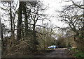
1
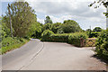
Green Lane passing Willow Farm
Green Lane is a long lane which is mainly single track with passing places.
Image: © Peter Facey
Taken: 3 Jul 2010
0.01 miles
4
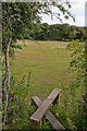
Field and footpath north of Green Lane at Emer Farm
Slightly elevated view due to photographer standing upon a stile.
Image: © Peter Facey
Taken: 5 Jul 2010
0.08 miles
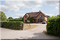
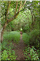
5
Parking area at entrance to Baddesley Common
Off Green Lane by Emer Farm
Image: © John Firth
Taken: 14 Apr 2013
0.08 miles
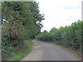
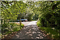
6
Path going towards Green Lane
Not a footpath but an overgrown track affording access to the nature reserve managed by Hampshire & Isle of Wight Wildlife Trust.
Image: © Peter Facey
Taken: 3 Jul 2010
0.08 miles
7
Green Lane passing Emer Farm
There is the start of a footpath to Crampmoor in right foreground. Also a footbridsge over Tadburn Lake (which is a stream).
Image: © Peter Facey
Taken: 5 Jul 2010
0.09 miles
8
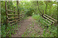
Curious paling west of Emer Farm
This track afford access from Green Lane to the area of Baddersley Common managed by Hampshire & Isle of Wight Wildlife Trust. This paling would make sense if there were an underpass or stream crossing beneath the path here, but there isn't.
Image: © Peter Facey
Taken: 3 Jul 2010
0.10 miles
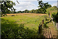
9
Footpath running SE from railway line at Crampmoor
Looking down from the railway embankment at the stile and fence protecting the railway line. The footpath runs straight ahead towards Green Lane.
Image: © Peter Facey
Taken: 5 Jul 2010
0.10 miles
10
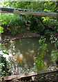
Tadburn Lake near Emer Farm
From footbridge. The lake is actually a stream running beside Green Lane in a tunnel of vegetation.
Image: © Peter Facey
Taken: 5 Jul 2010
0.10 miles