IMAGES TAKEN NEAR TO
Montfort Heights, Halterworth Lane, ROMSEY, SO51 9LP
Introduction
This page details the photographs taken nearby to Montfort Heights, Halterworth Lane, SO51 9LP by members of the Geograph project.
The Geograph project started in 2005 with the aim of publishing, organising and preserving representative images for every square kilometre of Great Britain, Ireland and the Isle of Man.

There are currently over 7.5m images from over14,400 individuals and you can help contribute to the project by visiting https://www.geograph.org.uk
Image Map (Loading...)


Getting Data...Please wait
Leaflet Map data © OpenStreetMap
Images are licensed for reuse under creativecommons.org/licenses/by-sa/2.0
Notes
- Clicking on the map will re-center to the selected point.
- The higher the marker number, the further away the image location is from the centre of the postcode.
Image Listing (8 Images Found)
Images are licensed for reuse under creativecommons.org/licenses/by-sa/2.0
Image
Details
Distance
2
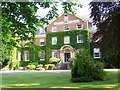
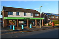
Montfort College, Romsey
This rather fine building has been converted into residential apartments. It was previously a Catholic seminary run by the Montfort Fathers.
Image: © David Martin
Taken: 23 May 2008
0.06 miles
8
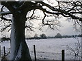
Field in Winter
Hampshire does get snow (just for one day in Feb 2009) - view from footpath south across fields occupied by some rather chilly sheep
Image: © Patrick Pavey
Taken: 2 Feb 2009
0.25 miles