IMAGES TAKEN NEAR TO
Toothill Road, ROMSEY, SO51 9LN
Introduction
This page details the photographs taken nearby to Toothill Road, SO51 9LN by members of the Geograph project.
The Geograph project started in 2005 with the aim of publishing, organising and preserving representative images for every square kilometre of Great Britain, Ireland and the Isle of Man.

There are currently over 7.5m images from over14,400 individuals and you can help contribute to the project by visiting https://www.geograph.org.uk
Image Map
Images are licensed for reuse under creativecommons.org/licenses/by-sa/2.0
Notes
- Clicking on the map will re-center to the selected point.
- The higher the marker number, the further away the image location is from the centre of the postcode.
Image Listing (3 Images Found)
Images are licensed for reuse under creativecommons.org/licenses/by-sa/2.0
Image
Details
Distance
1
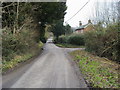
Toothill Road
Toothill Road nearing Middle Farm
Image: © Shaun Ferguson
Taken: 29 Jan 2009
0.08 miles
2
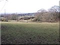
Footpath across fields at Toothill
This is the Toothill end of the path shown in Image
Image: © David Martin
Taken: 8 Mar 2010
0.12 miles
3
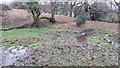
Path interrupted by stream
As so frequently seems to be the case on my walks, the marked path is intersected here by deep mud and flowing surface water. It proved possible to step across hummocks lower down the slope.
Image: © David Martin
Taken: 5 Jan 2019
0.17 miles