IMAGES TAKEN NEAR TO
Southampton Road, SO51 9LJ
Introduction
This page details the photographs taken nearby to Southampton Road, SO51 9LJ by members of the Geograph project.
The Geograph project started in 2005 with the aim of publishing, organising and preserving representative images for every square kilometre of Great Britain, Ireland and the Isle of Man.

There are currently over 7.5m images from over14,400 individuals and you can help contribute to the project by visiting https://www.geograph.org.uk
Image Map (Loading...)


Getting Data...Please wait
Leaflet Map data © OpenStreetMap
Images are licensed for reuse under creativecommons.org/licenses/by-sa/2.0
Notes
- Clicking on the map will re-center to the selected point.
- The higher the marker number, the further away the image location is from the centre of the postcode.
Image Listing (7 Images Found)
Images are licensed for reuse under creativecommons.org/licenses/by-sa/2.0
Image
Details
Distance
1

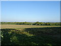
Ploughed Field Ashfield
This recently ploughed field on the west side of the A3057 is just south of Lower Ashfield Farm clost to the western end of Hoe Lane
Image: © Nigel Mykura
Taken: 26 Oct 2009
0.07 miles
2
Old Milestone by the A3057, north of Upper Ashfield Farm, Romsey Extra parish
Metal plate (Plate lost?) attached to stone post by the A3057, in parish of ROMSEY EXTRA (TEST VALLEY District), Upper Ashfield Farm, deep in blackthorn hedge opposite Upper Ashfield Farm, on West side of road. Romsey tombstone marker, erected by the Whiteparish, Romsey & Southampton turnpike trust in the 19th century.
Inscription reads:-
6 miles
TO SOTON
2 TO
ROMSEY
Grade II listed.
List Entry Number: 1093618 https://historicengland.org.uk/listing/the-list/list-entry/1093618
Milestone Society National ID: HA_SORO06.
Image: © K Lawrence
Taken: 26 May 2003
0.16 miles
3
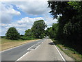
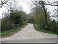
A3057 NNW from junction with Toothill Road
Image: © Alex McGregor
Taken: 6 Jul 2010
0.22 miles
4
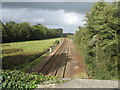
Railway from Spaniard's Lane bridge
Taken from a bridge which isn't public highway but forms a link between the A27 and Lee Lane, showing the railway line from Southampton to Romsey.
Image: © Kevin Jenkin
Taken: 21 Oct 2006
0.23 miles
7
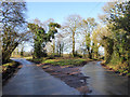
Which way to go?
Toothill Road approaches the A3057. A pivotal decision - it would have to be right and right again off the main road if heading north, to avoid Romsey to the east. There is no way of avoiding it and its busy roads to the west from here - the River Test is in the way with no crossings.
Image: © Robin Webster
Taken: 7 Feb 2017
0.25 miles