IMAGES TAKEN NEAR TO
Premier Way, ROMSEY, SO51 9AQ
Introduction
This page details the photographs taken nearby to Premier Way, SO51 9AQ by members of the Geograph project.
The Geograph project started in 2005 with the aim of publishing, organising and preserving representative images for every square kilometre of Great Britain, Ireland and the Isle of Man.

There are currently over 7.5m images from over14,400 individuals and you can help contribute to the project by visiting https://www.geograph.org.uk
Image Map
Images are licensed for reuse under creativecommons.org/licenses/by-sa/2.0
Notes
- Clicking on the map will re-center to the selected point.
- The higher the marker number, the further away the image location is from the centre of the postcode.
Image Listing (5 Images Found)
Images are licensed for reuse under creativecommons.org/licenses/by-sa/2.0
Image
Details
Distance
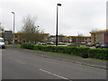
1
Abbey Park Industrial Estate, Romsey
A road inside the industrial estate, which is packed with buildings similar to these. Trees screen the estate from the A27.
Image: © Rosemary Oakeshott
Taken: 17 Dec 2007
0.13 miles
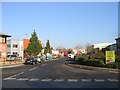
2
Abbey Park Industrial Estate, Romsey
The entrance to the estate. This seems spacious but once inside there is little free space - and little chance of driving at 30mph.
Image: © Rosemary Oakeshott
Taken: 17 Dec 2007
0.18 miles
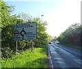
4

Electricity Substation at North Baddesley
This substation receives 33 KV power from Upton and Winchester substations, and supplies 11KV power to much of Romsey and North Baddesley.
Image: © Peter Facey
Taken: 2 May 2008
0.22 miles
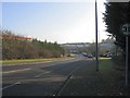
5
Luzborough Lane (A27) approaching roundabout
Image: © JThomas
Taken: 26 Apr 2022
0.24 miles