IMAGES TAKEN NEAR TO
Seward Rise, ROMSEY, SO51 8PE
Introduction
This page details the photographs taken nearby to Seward Rise, SO51 8PE by members of the Geograph project.
The Geograph project started in 2005 with the aim of publishing, organising and preserving representative images for every square kilometre of Great Britain, Ireland and the Isle of Man.

There are currently over 7.5m images from over14,400 individuals and you can help contribute to the project by visiting https://www.geograph.org.uk
Image Map (Loading...)


Getting Data...Please wait
Leaflet Map data © OpenStreetMap
Images are licensed for reuse under creativecommons.org/licenses/by-sa/2.0
Notes
- Clicking on the map will re-center to the selected point.
- The higher the marker number, the further away the image location is from the centre of the postcode.
Image Listing (8 Images Found)
Images are licensed for reuse under creativecommons.org/licenses/by-sa/2.0
Image
Details
Distance
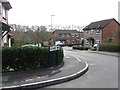
2
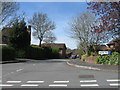
Halterworth Lane and Jenner Way junction
Image: © John Firth
Taken: 13 Apr 2013
0.10 miles
3
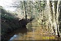
Tadburn Lake, Halterworth, Romsey
Despite its name Tadburn Lake is a river which flows through Romsey to the River Test. This view was taken looking westwards and downstream from under the Halterworth Road bridge.
Image: © Nigel Cox
Taken: 2 Mar 2004
0.17 miles
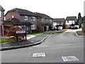
4
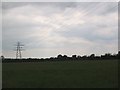
Fields at Halterworth, Romsey
Looking south from Halterworth Lane
Image: © Andrew McDonald
Taken: 12 Jun 2005
0.21 miles
8
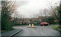
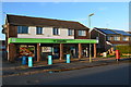
Romsey: Viney Avenue shops
The convenience store at the end of the parade now incorporates Viney Avenue Post Office, opened a couple of weeks ago to replace the Great Woodley branch on a nearby shopping precinct. It has extended opening times, including longer hours on a Sunday than most post offices offer on weekdays.
Image: © Chris Downer
Taken: 19 Dec 2010
0.24 miles