IMAGES TAKEN NEAR TO
Winchester Hill, ROMSEY, SO51 7ZA
Introduction
This page details the photographs taken nearby to Winchester Hill, SO51 7ZA by members of the Geograph project.
The Geograph project started in 2005 with the aim of publishing, organising and preserving representative images for every square kilometre of Great Britain, Ireland and the Isle of Man.

There are currently over 7.5m images from over14,400 individuals and you can help contribute to the project by visiting https://www.geograph.org.uk
Image Map (Loading...)


Getting Data...Please wait
Leaflet Map data © OpenStreetMap
Images are licensed for reuse under creativecommons.org/licenses/by-sa/2.0
Notes
- Clicking on the map will re-center to the selected point.
- The higher the marker number, the further away the image location is from the centre of the postcode.
Image Listing (48 Images Found)
Images are licensed for reuse under creativecommons.org/licenses/by-sa/2.0
Image
Details
Distance
4
Chirk Place, just off the Winchester Road
Image: © Basher Eyre
Taken: 19 Feb 2009
0.03 miles
5
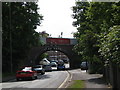
Railway Bridge, Romsey
There are three railway bridges in Romsey. This one carries the line to Eastleigh, and is one of two that large lorries regularly get stuck under (in spite of all the warning signs!).
Image: © Andrew McDonald
Taken: 15 May 2005
0.04 miles
6
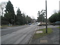
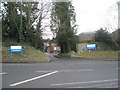
Junction of Winchester Road with the Winchester Road
Image: © Basher Eyre
Taken: 19 Feb 2009
0.06 miles
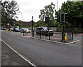
8
Junction of Cupernham Lane and Winchester Hill, Romsey
The southern end of Cupernham Lane, viewed across the A3090 Winchester Hill.
Image: © Jaggery
Taken: 31 May 2015
0.08 miles
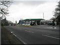
9

Junction of Cupernham Lane and Winchester Road
Image: © Peter Facey
Taken: 29 Sep 2011
0.08 miles
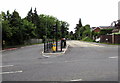
10
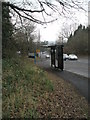
Double pelican crossing, Winchester Hill, Romsey
Across the A3090 Winchester Hill a few metres west of the Cupernham Lane junction. http://www.geograph.org.uk/photo/4504203 There are separate pedestrian-operated traffic lights for each carriageway. Chambers Dictionary states that the term pelican crossing is adapted from "pedestrian light controlled crossing".
Image: © Jaggery
Taken: 31 May 2015
0.09 miles