IMAGES TAKEN NEAR TO
Primrose Way, ROMSEY, SO51 7RF
Introduction
This page details the photographs taken nearby to Primrose Way, SO51 7RF by members of the Geograph project.
The Geograph project started in 2005 with the aim of publishing, organising and preserving representative images for every square kilometre of Great Britain, Ireland and the Isle of Man.

There are currently over 7.5m images from over14,400 individuals and you can help contribute to the project by visiting https://www.geograph.org.uk
Image Map (Loading...)


Getting Data...Please wait
Leaflet Map data © OpenStreetMap
Images are licensed for reuse under creativecommons.org/licenses/by-sa/2.0
Notes
- Clicking on the map will re-center to the selected point.
- The higher the marker number, the further away the image location is from the centre of the postcode.
Image Listing (56 Images Found)
Images are licensed for reuse under creativecommons.org/licenses/by-sa/2.0
Image
Details
Distance
6
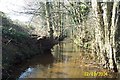
Tadburn Lake, Halterworth, Romsey
Despite its name Tadburn Lake is a river which flows through Romsey to the River Test. This view was taken looking westwards and downstream from under the Halterworth Road bridge.
Image: © Nigel Cox
Taken: 2 Mar 2004
0.10 miles
9
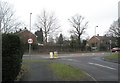
Junction of Viney Avenue with the Winchester Road
Image: © Basher Eyre
Taken: 19 Feb 2009
0.11 miles
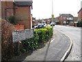
10
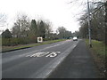
Romsey town boundary on the Winchester Road
Image: © Basher Eyre
Taken: 19 Feb 2009
0.11 miles