IMAGES TAKEN NEAR TO
Woodley Lane, ROMSEY, SO51 7PE
Introduction
This page details the photographs taken nearby to Woodley Lane, SO51 7PE by members of the Geograph project.
The Geograph project started in 2005 with the aim of publishing, organising and preserving representative images for every square kilometre of Great Britain, Ireland and the Isle of Man.

There are currently over 7.5m images from over14,400 individuals and you can help contribute to the project by visiting https://www.geograph.org.uk
Image Map (Loading...)


Getting Data...Please wait
Leaflet Map data © OpenStreetMap
Images are licensed for reuse under creativecommons.org/licenses/by-sa/2.0
Notes
- Clicking on the map will re-center to the selected point.
- The higher the marker number, the further away the image location is from the centre of the postcode.
Image Listing (31 Images Found)
Images are licensed for reuse under creativecommons.org/licenses/by-sa/2.0
Image
Details
Distance
3
Braishfield Road south of junction with School Road
Image: © Stuart Logan
Taken: 11 Sep 2013
0.07 miles
4
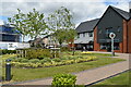
New commercial centre, Radcliffe Row
Grassy area and local shops on the Abbotswood development, Romsey.
Image: © David Martin
Taken: 13 Jun 2022
0.11 miles
5
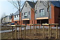
New village centre
New shop units nearing completion at Abbotswood village centre.
Image: © David Martin
Taken: 7 Apr 2019
0.11 miles
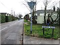
8
Junction of Winterbourne Road and Tavistock Close
Image: © Basher Eyre
Taken: 19 Feb 2009
0.14 miles
9

Snowscene at Ganger Farm Lane Romsey
View of snowbound Ganger Farm Lane from junction of Braishfield Road, Romsey
Image: © John Firth
Taken: Unknown
0.15 miles