IMAGES TAKEN NEAR TO
Belbins Business Park, Cupernham Lane, ROMSEY, SO51 7JF
Introduction
This page details the photographs taken nearby to Belbins Business Park, Cupernham Lane, SO51 7JF by members of the Geograph project.
The Geograph project started in 2005 with the aim of publishing, organising and preserving representative images for every square kilometre of Great Britain, Ireland and the Isle of Man.

There are currently over 7.5m images from over14,400 individuals and you can help contribute to the project by visiting https://www.geograph.org.uk
Image Map
Images are licensed for reuse under creativecommons.org/licenses/by-sa/2.0
Notes
- Clicking on the map will re-center to the selected point.
- The higher the marker number, the further away the image location is from the centre of the postcode.
Image Listing (9 Images Found)
Images are licensed for reuse under creativecommons.org/licenses/by-sa/2.0
Image
Details
Distance
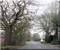
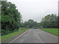
2
Junction of Cupernham Lane with Sandy Lane
Sandy Lane junction, looking west towards Belbins. The road provides a link from the A3057 to the A3090 for traffic to avoid Romsey town centre.
Image: © Patrick Pavey
Taken: 5 Jan 2007
0.09 miles
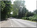
4
Junction of Culpernham Lane and Sandy Lane
Image: © Stuart Logan
Taken: 5 Oct 2012
0.14 miles

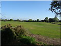
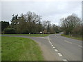
7

Newly completed housing in Treviglio Close, Romsey
Image: © David Martin
Taken: 19 Jan 2023
0.19 miles
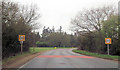
8
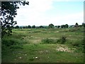
View north from Sandy Lane
Taken adjacent to a disused pit between Sandy Lane and Abbotswood Farm
Image: © David Martin
Taken: 12 Jun 2010
0.21 miles