IMAGES TAKEN NEAR TO
Battenberg Close, ROMSEY, SO51 7AG
Introduction
This page details the photographs taken nearby to Battenberg Close, SO51 7AG by members of the Geograph project.
The Geograph project started in 2005 with the aim of publishing, organising and preserving representative images for every square kilometre of Great Britain, Ireland and the Isle of Man.

There are currently over 7.5m images from over14,400 individuals and you can help contribute to the project by visiting https://www.geograph.org.uk
Image Map
Images are licensed for reuse under creativecommons.org/licenses/by-sa/2.0
Notes
- Clicking on the map will re-center to the selected point.
- The higher the marker number, the further away the image location is from the centre of the postcode.
Image Listing (4 Images Found)
Images are licensed for reuse under creativecommons.org/licenses/by-sa/2.0
Image
Details
Distance
1
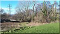
Slope below the power lines
This slope separates areas of new housing in Battenberg Close (above) and Oxlease Meadows (below). There is extensive new housebuilding still under way on this edge of the River Test floodplain.
Image: © David Martin
Taken: 19 Jan 2023
0.05 miles
2
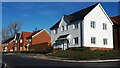
Newly completed housing in Treviglio Close, Romsey
Image: © David Martin
Taken: 19 Jan 2023
0.08 miles
3
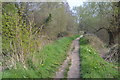
Towpath beside former canal at Fishlake Meadows
Image: © David Martin
Taken: 7 Apr 2019
0.18 miles