IMAGES TAKEN NEAR TO
Embley Lane, ROMSEY, SO51 6DN
Introduction
This page details the photographs taken nearby to Embley Lane, SO51 6DN by members of the Geograph project.
The Geograph project started in 2005 with the aim of publishing, organising and preserving representative images for every square kilometre of Great Britain, Ireland and the Isle of Man.

There are currently over 7.5m images from over14,400 individuals and you can help contribute to the project by visiting https://www.geograph.org.uk
Image Map (Loading...)


Getting Data...Please wait
Leaflet Map data © OpenStreetMap
Images are licensed for reuse under creativecommons.org/licenses/by-sa/2.0
Notes
- Clicking on the map will re-center to the selected point.
- The higher the marker number, the further away the image location is from the centre of the postcode.
Image Listing (5 Images Found)
Images are licensed for reuse under creativecommons.org/licenses/by-sa/2.0
Image
Details
Distance
2

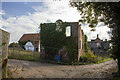
Derelict vineyard, Wellow
A sad sight: the former Wellow vineyard, now increasingly overgrown
Image: © David Martin
Taken: 26 Apr 2008
0.21 miles
4
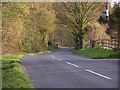
View down Woodington Lane
The road descends quite steeply here towards Wellow, past the site of the old Wellow Vineyard, no longer trading at the date this photograph was taken, although still shown on the 1:50,000 map.
Image: © David Martin
Taken: 17 Apr 2008
0.23 miles
5

Embley Lane
Embley Lane, junction with Tanners Lane
Image: © P Gaskell
Taken: Unknown
0.25 miles